IMAGES TAKEN NEAR TO
St. Thomas Road, LONDON, W4 3LD
Introduction
This page details the photographs taken nearby to St. Thomas Road, W4 3LD by members of the Geograph project.
The Geograph project started in 2005 with the aim of publishing, organising and preserving representative images for every square kilometre of Great Britain, Ireland and the Isle of Man.

There are currently over 7.5m images from over14,400 individuals and you can help contribute to the project by visiting https://www.geograph.org.uk
Image Map
Images are licensed for reuse under creativecommons.org/licenses/by-sa/2.0
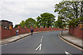
Notes
- Clicking on the map will re-center to the selected point.
- The higher the marker number, the further away the image location is from the centre of the postcode.
Image Listing (131 Images Found)
Images are licensed for reuse under creativecommons.org/licenses/by-sa/2.0
Image
Details
Distance
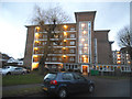
1
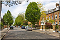
Approaching Grove Park Terrace
A class 450 electric unit on route to Hounslow from Waterloo travels between Chiswick and Kew Bridge stations. On the right is an array of cabinets probably containing electrical equipment related to the functioning of the level crossing ahead of the train. Further down the line Grove Park Bridge is visible.
Image: © Martin Addison
Taken: 7 May 2010
0.04 miles
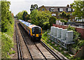
2
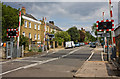
Hounslow Loop line
Looking towards the Grove Terrace level crossing from Grove Park bridge. No trains were running today, a Sunday - engineering work was in progress beyond the level crossing and probably elsewhere.
Image: © Robin Webster
Taken: 13 May 2012
0.05 miles
3
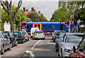
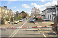
Grove Park Terrace
Cars wait at the barriers as a train passes over the level crossing in the middle of this suburban side street.
Image: © Martin Addison
Taken: 7 May 2010
0.07 miles
4
Grove Park Gardens
A broad, quiet suburban street.
Image: © Martin Addison
Taken: 7 May 2010
0.07 miles
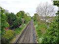
5
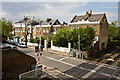
Level Crossing on Grove Park Terrace
Level crossings are not particularly common in London, particularly inside the A406 / A205 ring. Many that existed in the early days of the railways have been replaced by bridges or by redirecting the road under the line. The traffic on this road probably doesn't justify such expense.
Image: © Martin Addison
Taken: 7 May 2010
0.08 miles
7
Grove Park Terrace
Houses on the terrace seen from the pedestrian footbridge provided by the level crossing that splits this street in two.
Image: © Martin Addison
Taken: 7 May 2010
0.09 miles
8

Sutton Court Road Chiswick
Junction of Lawford Road is on the right
Image: © David Howard
Taken: 21 Jun 2008
0.10 miles
9
Grove Park Bridge
This bridge connects Grove Park Road to the south of the railway line between Chiswick and Kew Bridge with Sutton Court Road on the other side. The road layout suggests that the bridge was built as an after-thought and it possibly replaced a level-crossing.
Image: © Martin Addison
Taken: 7 May 2010
0.11 miles