IMAGES TAKEN NEAR TO
Chiswick Wharf, LONDON, W4 2SR
Introduction
This page details the photographs taken nearby to Chiswick Wharf, W4 2SR by members of the Geograph project.
The Geograph project started in 2005 with the aim of publishing, organising and preserving representative images for every square kilometre of Great Britain, Ireland and the Isle of Man.

There are currently over 7.5m images from over14,400 individuals and you can help contribute to the project by visiting https://www.geograph.org.uk
Image Map
Images are licensed for reuse under creativecommons.org/licenses/by-sa/2.0
Notes
- Clicking on the map will re-center to the selected point.
- The higher the marker number, the further away the image location is from the centre of the postcode.
Image Listing (215 Images Found)
Images are licensed for reuse under creativecommons.org/licenses/by-sa/2.0
Image
Details
Distance
1
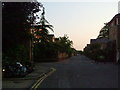
Pumping Station Road, W4
All this has changed in the past 15 years or so.
Image: © Phillip Perry
Taken: 13 May 2008
0.02 miles
2
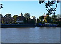
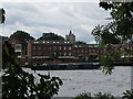
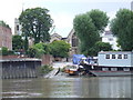
View across the Thames to Chiswick
In the centre is Church Wharf, and the tower of St Nicholas' Church.
Image: © Eirian Evans
Taken: 20 Oct 2010
0.02 miles
3
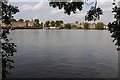
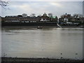
Riverfront at Chiswick
View over the River Thames to Chiswick.
Image: © Philip Halling
Taken: 24 Sep 2011
0.02 miles
4
View to Chiswick
View to Chiswick from across the River Thames.
Image: © Philip Halling
Taken: 24 Sep 2011
0.03 miles
6
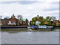
Across the Thames to Chiswick
Looking across the River Thames to the tower of St Nicholas Church Chiswick
Image: © Shaun Ferguson
Taken: 18 Dec 2008
0.03 miles
7
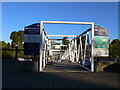
Former Chiswick Ferry landing
The drawdock and causeway are at the north bank landing for the foot ferry whose south bank landing was at or close to the camera position. Although the ferry is shown on maps up to the 1930s, The Victoria County History misleadingly remarks it was still used up to the 1890s, citing a map of that date. Why didn't the historian, publishing in 1982, look at later maps? When was the true date the ferry ceased? There is still a public footpath down the causeway. The church is St. Nicholas, Chiswick.
Image: © Robin Webster
Taken: 14 Apr 2012
0.03 miles
8
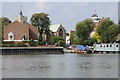
Chiswick Pier
Chiswick Pier is managed by the Chiswick Pier Trust, and is staffed mainly by volunteers.
Image: © Eirian Evans
Taken: 20 Oct 2010
0.04 miles
9
Slipway at Chiswick
A slipway into the Thames from the north bank of the river at Chiswick.
Image: © Malc McDonald
Taken: 2 Jul 2011
0.04 miles
10
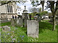
Hogarth's tomb in Chiswick Churchyard
Hogarth's tomb is the one with the urn on top. The tomb was erected soon after the death of Hogarth's sister Anne in 1771. Its classical style was then fashionable.
William Hogarth, often called 'the Father of English Painting' is most famous for his series of moralising paintings like 'The Rake's Progress' and 'Marriage-a-la-mode'. A business man as well as an artist, Hogarth published prints of his work from his house in Leicester Square. By 1749, Hogarth could afford to buy a modest country house in Chiswick. This is now known as Hogarth's House and since 1904 has been a museum in his memory.
Members of Hogarth's family are commemorated on the monument: his mother-in-law, widow of the court painter Sir James Thornhill, on the west face, and his sister Anne and Mrs Thornhill's cousin, Mary Lewis on the south. Mary inherited Hogarth's House and lived there until her death in 1808.
On the east side of the tomb the inscription reads: "Here lies the Body of WILLIAM HOGARTH ESQR who died October the 26th 1764 aged 67 years" "MRS JANE HOGARTH wife of WILLIAM HOGARTH ESQR Obit the 13th November 1789 Aetat 80 years" Strange that it was the later one which switched partly into Latin.
The principal inscription on the north face is the epitaph to Hogarth written by his friend David Garrick, the celebrated actor. It starts "Farewell great Painter of Mankind."
Image: © Marathon
Taken: 6 May 2016
0.04 miles