IMAGES TAKEN NEAR TO
Marlborough Crescent, LONDON, W4 1HF
Introduction
This page details the photographs taken nearby to Marlborough Crescent, W4 1HF by members of the Geograph project.
The Geograph project started in 2005 with the aim of publishing, organising and preserving representative images for every square kilometre of Great Britain, Ireland and the Isle of Man.

There are currently over 7.5m images from over14,400 individuals and you can help contribute to the project by visiting https://www.geograph.org.uk
Image Map
Images are licensed for reuse under creativecommons.org/licenses/by-sa/2.0
Notes
- Clicking on the map will re-center to the selected point.
- The higher the marker number, the further away the image location is from the centre of the postcode.
Image Listing (176 Images Found)
Images are licensed for reuse under creativecommons.org/licenses/by-sa/2.0
Image
Details
Distance
1
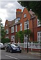
Houses, Bedford Park
Built in the 1880s to designs by architect E.J. May.
Image: © Jim Osley
Taken: 17 Jul 2015
0.01 miles
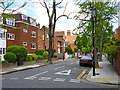
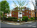
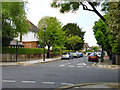
3
Marlborough Crescent, Bedford
The north-western edge of the original part of Bedford Park, with most buildings Listed Grade II. The first house on the left (not the modern flats!) is probably by Norman Shaw; its neighbour definitively so.
Image: © Alan Murray-Rust
Taken: 10 Jan 2012
0.02 miles
4
The Orchard / Bedford Road, W4
Shows the location of Image
Image: © Mike Quinn
Taken: 16 Jul 2008
0.04 miles
5
St James' Court
A block of flats on the corner of Bedford Road and Marlborough Crescent, W4.
Image: © Robin Webster
Taken: 13 May 2012
0.05 miles
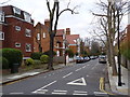
8
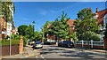
Corner of The Orchard and Bedford Road
Part of the Bedford Park conservation area, complete with period style gas lamp post.
Image: © James Emmans
Taken: 2 Jun 2022
0.06 miles
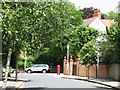
9
Esmond Road, W4
In the Bedford Park area of Acton.
Image: © Robin Webster
Taken: 13 May 2012
0.06 miles
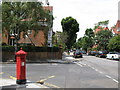
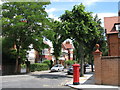
10
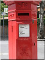
Penfold postbox, The Orchard / Bedford Road, W4 - royal cipher and crest
See Image
Image: © Mike Quinn
Taken: 16 Jul 2008
0.06 miles