IMAGES TAKEN NEAR TO
Pierrepoint Road, LONDON, W3 9JS
Introduction
This page details the photographs taken nearby to Pierrepoint Road, W3 9JS by members of the Geograph project.
The Geograph project started in 2005 with the aim of publishing, organising and preserving representative images for every square kilometre of Great Britain, Ireland and the Isle of Man.

There are currently over 7.5m images from over14,400 individuals and you can help contribute to the project by visiting https://www.geograph.org.uk
Image Map
Images are licensed for reuse under creativecommons.org/licenses/by-sa/2.0
Notes
- Clicking on the map will re-center to the selected point.
- The higher the marker number, the further away the image location is from the centre of the postcode.
Image Listing (37 Images Found)
Images are licensed for reuse under creativecommons.org/licenses/by-sa/2.0
Image
Details
Distance
1
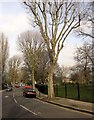
Rosemont Road, Acton
Leading away from the A4000 Steyne Road. On the right is Springfield Gardens.
Image: © Derek Harper
Taken: 21 Mar 2013
0.14 miles
2
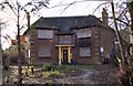
House in Lynton Road, Acton, W3
For many years this view of the house was almost completely obscured by trees and overgrown shrubs. For a while it appeared that renovation work was being undertaken. Unfortunately, the house was demolished in December 2010.
Image: © MrC
Taken: 2 Jan 2010
0.14 miles
3
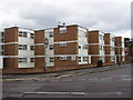
Oak Tree Court, Acton
This block of flats is at the junction of Lynton Road and Pierrepoint Road.
Image: © David Hawgood
Taken: 20 May 2006
0.14 miles
4
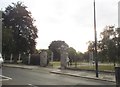
The entrance to Springfield Gardens on Horn Lane
Image: © David Howard
Taken: 27 Jun 2015
0.15 miles
5
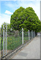
Park Railings, Springfield Gardens
This is the park boundary beside Horn Lane. The Gardens were opened in 1934 and these period railings are lucky to have survived the WW2 scrap metal raids that came a few years later.
Image: © Des Blenkinsopp
Taken: 13 Apr 2017
0.16 miles
6
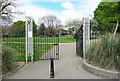
Gates into Springfield Gardens
A small park beside Horn Lane, created from wasteland in 1934 with an open-air theatre, which was subsequently pulled down. The gardens are called Springfield after the spring in Rosemont Road, on the west side of the park, which flows into Stamford Brook.
Image: © Des Blenkinsopp
Taken: 13 Apr 2017
0.16 miles
7
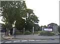
The entrance to Springfield Gardens on Horn Lane
Image: © David Howard
Taken: 27 Jun 2015
0.18 miles
8

Moreton Tower, Acton
One of a pair of tower blocks close to the centre of Acton.
Image: © Alan Murray-Rust
Taken: 10 Jan 2012
0.18 miles

10

Rufford Tower and Moreton Tower Acton
Two 22 storey blocks of flats on the Steyne housing estate, completed in 1968.
Image: © Rod Allday
Taken: 18 Aug 2012
0.19 miles