IMAGES TAKEN NEAR TO
Billington Mews, LONDON, W3 9BX
Introduction
This page details the photographs taken nearby to Billington Mews, W3 9BX by members of the Geograph project.
The Geograph project started in 2005 with the aim of publishing, organising and preserving representative images for every square kilometre of Great Britain, Ireland and the Isle of Man.

There are currently over 7.5m images from over14,400 individuals and you can help contribute to the project by visiting https://www.geograph.org.uk
Image Map
Images are licensed for reuse under creativecommons.org/licenses/by-sa/2.0
Notes
- Clicking on the map will re-center to the selected point.
- The higher the marker number, the further away the image location is from the centre of the postcode.
Image Listing (239 Images Found)
Images are licensed for reuse under creativecommons.org/licenses/by-sa/2.0
Image
Details
Distance
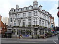
1
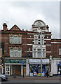
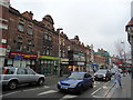
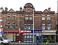
229/231 High Street, Acton
Retail premises with some fine terracotta decoration.
Image: © Alan Murray-Rust
Taken: 10 Jan 2012
0.02 miles
2
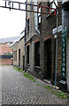
Billington Mews, Acton
A narrow cobbled street off High Street, Acton.
Image: © Martin Addison
Taken: 31 Oct 2013
0.02 miles
3
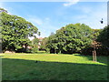
Woodlands Park with ice house, Acton
Woodlands is a small park near the centre of Acton.
The domed brick structure visible under the tree on the left is the top of an ice house. It was in the 6-acre garden of a house "Woodlands" demolished in 1903. The ice house and the nearby pond which provided the ice were restored in 2006.
Image: © David Hawgood
Taken: 3 Sep 2023
0.02 miles
5
219-223 High Street, Acton
Retail premises with some fine terracotta decoration in need of a clean-up.
Image: © Alan Murray-Rust
Taken: 10 Jan 2012
0.02 miles
6
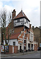
The old fire station, Acton
Built in 1899 to the design of the Acton Council Surveyor, D J Ebbetts to house the Council's two new fire engines. The tower served as a lookout as well as for drying hoses. It was replaced by a new station in Gunnersbury Lane in 1939. Source: http://www.actonhistory.co.uk/acton/page1.html
Image: © Alan Murray-Rust
Taken: 10 Jan 2012
0.03 miles
7
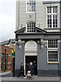
The Duke's Head, Acton (detail)
The original entrance to the restaurant, presumably on the first floor. Note also the sculpted King's Head http://www.geograph.org.uk/photo/2766897 at first floor level.
Image: © Alan Murray-Rust
Taken: 10 Jan 2012
0.03 miles
8
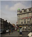
Kings Head, Acton
The pub (see also http://www.geograph.org.uk/search.php?i=40510132 ) faces the junction of King Street (right, now pedestrianised) with the A4020 High Street (left); Crown Street is off to the left.
Image: © Derek Harper
Taken: 21 Mar 2013
0.04 miles
9
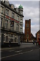
Acton High Street: St Mary's church and the Kings Head pub
Image: © Christopher Hilton
Taken: 23 Mar 2015
0.04 miles
10
The Kings head Hotel & Pub, Acton, London W3
On High Street.
Image: © JThomas
Taken: 13 Apr 2019
0.04 miles