IMAGES TAKEN NEAR TO
Osborne Road, LONDON, W3 8SN
Introduction
This page details the photographs taken nearby to Osborne Road, W3 8SN by members of the Geograph project.
The Geograph project started in 2005 with the aim of publishing, organising and preserving representative images for every square kilometre of Great Britain, Ireland and the Isle of Man.

There are currently over 7.5m images from over14,400 individuals and you can help contribute to the project by visiting https://www.geograph.org.uk
Image Map
Images are licensed for reuse under creativecommons.org/licenses/by-sa/2.0
Notes
- Clicking on the map will re-center to the selected point.
- The higher the marker number, the further away the image location is from the centre of the postcode.
Image Listing (130 Images Found)
Images are licensed for reuse under creativecommons.org/licenses/by-sa/2.0
Image
Details
Distance
1
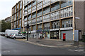
Shops on Hanbury Road
Located on the ground floor level of Buchan House on the South Acton Estate. Most of the 'shops' are now given over to community associations and services. The corner Post Office has closed - its premises now used by SAFE Family Support Service.
Image: © Martin Addison
Taken: 31 Oct 2013
0.08 miles
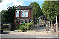
2
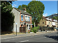
The only old house on the street
This appears to owe its survival to being the school caretaker's house. It is certainly behind the same railings as the school yard.
Image: © Robin Webster
Taken: 22 Sep 2012
0.09 miles
3
The only old house on the street
This appears to owe its survival to being the school caretaker's house. It is certainly behind the same railings as the Berrymede Junior School yard.
Image: © Robin Webster
Taken: 22 Sep 2012
0.09 miles
4
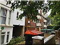
Housing, Avenue Crescent, Acton W3
The building on the left has a green plaque from Ealing Civic Society denoting that William Willett (the originator of daylight saving time) lived at this address 1882-1894.
https://en.wikipedia.org/wiki/William_Willett
Image: © Philip Cornwall
Taken: 4 Oct 2020
0.10 miles
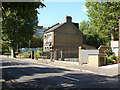
5
Acton: Bollo Bridge Road
All is changed around here and it is hard to find anything that has not been built recently, but this (presumably schoolkeeper's) house and the school behind it are from an earlier period.
Image: © Dr Neil Clifton
Taken: 19 Sep 2012
0.10 miles
6
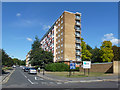
Grahame Tower, South Acton Estate, 2012
Now demolished and replaced with medium rise flats.
Image: © Robin Webster
Taken: 22 Sep 2012
0.10 miles
7
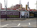
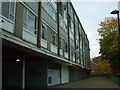
Uberhaus under construction, South Acton
The Daily Telegraph in an article "Duplex apartments: going up in the world" defines Uberhaus as "a name dreamed up by one developer to make its penthouses sound different". So it's a maisonette on the top two floors of a block of flats, with its own internal staircase. This is in South Acton, a large area of council tower blocks now being regenerated, described by the developer as "just minutes from fashionable Chiswick".
Image: © David Hawgood
Taken: 10 May 2014
0.13 miles
8
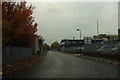
Roslin Road, W3
This small part of South Acton was known as 'Soapsud Island', due to the amount of industrial laundries in the area. There's just one left nowadays.
Image: © Phillip Perry
Taken: 31 Oct 2010
0.14 miles
9
Hardy Court, W3
One of the many dreary and depressing buildings in this part of Acton, part of the South Acton estate.
Image: © Phillip Perry
Taken: 31 Oct 2010
0.14 miles
10

Osborne Hotel, Osborne Road, Acton.
Formerly The Crown PH (Watney). Converted to B&B in 1999.
Image: © Andrew Riley
Taken: 29 Jul 2015
0.15 miles