IMAGES TAKEN NEAR TO
Park Drive, LONDON, W3 8NB
Introduction
This page details the photographs taken nearby to Park Drive, W3 8NB by members of the Geograph project.
The Geograph project started in 2005 with the aim of publishing, organising and preserving representative images for every square kilometre of Great Britain, Ireland and the Isle of Man.

There are currently over 7.5m images from over14,400 individuals and you can help contribute to the project by visiting https://www.geograph.org.uk
Image Map
Images are licensed for reuse under creativecommons.org/licenses/by-sa/2.0
Notes
- Clicking on the map will re-center to the selected point.
- The higher the marker number, the further away the image location is from the centre of the postcode.
Image Listing (180 Images Found)
Images are licensed for reuse under creativecommons.org/licenses/by-sa/2.0
Image
Details
Distance
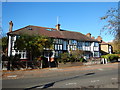
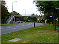
2
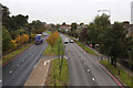
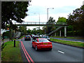
A406 - North Circular Road
Looking northbound from the footbridge beside Princes Avenue. On the left is Gunnersbury Park. The road on the right is Park Place Drive which is actually an access road running between the houses on the North Circular Road and those on Park Drive. The A406 traffic is surprisingly light for a Friday lunchtime.
Image: © Martin Addison
Taken: 31 Oct 2013
0.05 miles
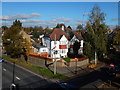
3
Houses on North Circular Road
Viewed through a gap in the fence at Gunnersbury Park.
Image: © Thomas Nugent
Taken: 26 Sep 2011
0.05 miles
4
Gunnersbury - Houses next to the A406
View from footbridge over the A406. The housing estate could be built on the original Gunnersbury Park land. One road called is Park Drive.
Construction cranes in the distance.
Wikipedia : https://en.wikipedia.org/wiki/Gunnersbury
Image: © James Emmans
Taken: 6 Nov 2016
0.06 miles
5
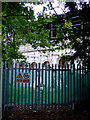
The old stables in Gunnersbury Park
Waiting to be restored.
Image: © Thomas Nugent
Taken: 26 Sep 2011
0.07 miles
6
Stable Blocks, Gunnersbury Park
Undergoing repair and consolidation work using Section 106 development grant funding, the Stable Blocks in Gunnersbury Park along with the other buildings are on the English Heritage 'At Risk' register. The east block is Grade II* listed whilst the West block is Grade II.
Image: © Martin Addison
Taken: 31 Oct 2013
0.07 miles
7

Pedestrian footbridge, Gunnersbury Avenue, W3
A footbridge crossing the busy North Circular Road.
Image: © Phillip Perry
Taken: 5 Jun 2011
0.07 miles
8
Footbridge over Gunnersbury Avenue
Provides safe access to Gunnersbury Park which is on the right.
Image: © Thomas Nugent
Taken: 9 Oct 2011
0.07 miles
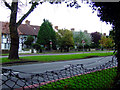
9
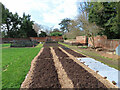
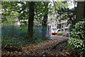
Community garden in Gunnersbury Park
The garden is prepared for spring planting.
Image: © David Hawgood
Taken: 14 Mar 2022
0.08 miles
10
Footbridge over Gunnersbury Avenue
Provides safe access to Gunnersbury Park from the east side of Gunnersbury Avenue.
Image: © Thomas Nugent
Taken: 9 Oct 2011
0.08 miles