IMAGES TAKEN NEAR TO
Perryn Road, LONDON, W3 7NA
Introduction
This page details the photographs taken nearby to Perryn Road, W3 7NA by members of the Geograph project.
The Geograph project started in 2005 with the aim of publishing, organising and preserving representative images for every square kilometre of Great Britain, Ireland and the Isle of Man.

There are currently over 7.5m images from over14,400 individuals and you can help contribute to the project by visiting https://www.geograph.org.uk
Image Map
Images are licensed for reuse under creativecommons.org/licenses/by-sa/2.0
Notes
- Clicking on the map will re-center to the selected point.
- The higher the marker number, the further away the image location is from the centre of the postcode.
Image Listing (55 Images Found)
Images are licensed for reuse under creativecommons.org/licenses/by-sa/2.0
Image
Details
Distance
2
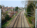
North London Line
Looking north. The overhead wires extend as far south as Acton Central, where electric trains are obliged to switch to third rail.
Image: © Robin Webster
Taken: 27 Mar 2011
0.06 miles
3
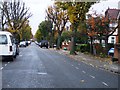
Acton: Shaa Road
To the stranger casually looking at a street map Shaa Road looks like a spelling mistake! Nonetheless here it is on site, complete with its road name plate and the old Ordnance Survey map of 1896 shows it with this spelling. A little Googling soon threw up the possible answer. It seems that the road is probably named after Sir Edmund Shaa, a goldsmith who was Mayor of London in 1482 and 1483 and an influential figure of the time in his dealings with Royalty. This is confirmed to a certain extent by the existence of The Goldsmith's Arms pub just around the corner from the other end of Shaa Road.
The original properties in Shaa Road appear to have been built in the 1880s by George Wright and the area is now part of the Acton Park Conservation Area. This view is taken from Perryn Road.
Image: © Nigel Cox
Taken: 13 Oct 2010
0.07 miles
4
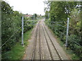
Acton: North London Line
This view was taken from the footbridge between Perryn Road and Shakespeare Road, and is looking in the opposite direction from Image The houses to the left are on St Dunstan's Avenue.
Image: © Nigel Cox
Taken: 13 Oct 2010
0.07 miles
5
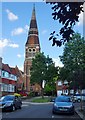
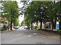
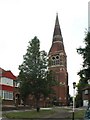
Vyner Road, East Acton
The church is St Dunstan's.
Image: © Stefan Czapski
Taken: 17 Jul 2016
0.09 miles
6
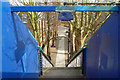
Down the steps to Perryn Road
The footbridge over the railway carries the footpath connecting Perryn Road with Goldsmith Avenue.
Image: © Robin Webster
Taken: 27 Mar 2011
0.10 miles
7
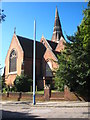
East Acton: St Dunstan's Church
Given the local connection with goldsmiths it is not surprising that the local church should be dedicated to their patron saint, St Dunstan. This is the tower of the church which was built between 1878 and 1879. The church is built in the Decorated style of red brick with white Doulting stone dressings. The tower is at the south-west corner of the church and its broach spire rises to about 140 feet about ground level. It houses a single bell which, after hanging silent for many years, was repaired and returned to operation in the 1990s. This is the view from Vyner Road.
Image: © Nigel Cox
Taken: 13 Oct 2010
0.11 miles
8
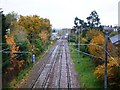
North London Line I, W3
Looking towards Acton Central station which can just be seen.
Image: © Phillip Perry
Taken: 8 Nov 2008
0.12 miles
9
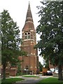
St Dunstan & St Thomas, Friars Place Lane, Acton
Image: © John Salmon
Taken: 3 Aug 2004
0.12 miles
10
St Dunstan's Church
In the Parish of St Dunstan with St Thomas in East Acton.
Image: © Rod Allday
Taken: 18 Aug 2012
0.12 miles