IMAGES TAKEN NEAR TO
Ashfield Road, LONDON, W3 7JF
Introduction
This page details the photographs taken nearby to Ashfield Road, W3 7JF by members of the Geograph project.
The Geograph project started in 2005 with the aim of publishing, organising and preserving representative images for every square kilometre of Great Britain, Ireland and the Isle of Man.

There are currently over 7.5m images from over14,400 individuals and you can help contribute to the project by visiting https://www.geograph.org.uk
Image Map
Images are licensed for reuse under creativecommons.org/licenses/by-sa/2.0
Notes
- Clicking on the map will re-center to the selected point.
- The higher the marker number, the further away the image location is from the centre of the postcode.
Image Listing (54 Images Found)
Images are licensed for reuse under creativecommons.org/licenses/by-sa/2.0
Image
Details
Distance
1
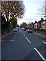
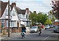
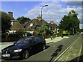
First Avenue, W3
This end of the road has 1930's built houses.
Image: © Phillip Perry
Taken: 9 Nov 2008
0.02 miles
3
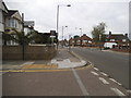
Old Oak Road at the junction of Ashfield Road
Image: © David Howard
Taken: 13 Jun 2015
0.05 miles
4
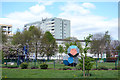
Trinity Way Open Space
A small local park looked after by Ealing Borough.
Image: © Des Blenkinsopp
Taken: 13 Apr 2017
0.06 miles
5
Cycling along Ashfield Road
A very random point and shoot picture of some decidedly non-lycra cyclists on a suburban side street.
Image: © Des Blenkinsopp
Taken: 13 Apr 2017
0.07 miles
6
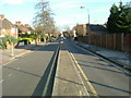
Steventon Road, W12
A rather unusual way of dividing a road, it's not a dual carriageway as we would know it and you can only drive down the right hand lane as you look at it. It's only one way going away from the picture, yet on the left side is access to a few houses. This has to be about 100 yards/metres long. Also see:Image
Image: © Phillip Perry
Taken: 1 Feb 2008
0.07 miles
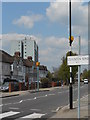
7
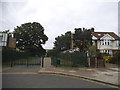
Sir Alexander Road & Sir Alexander Close, W3
The rather curiously named Sir Alexander Road & Sir Alexander Close, former police section houses and prison officers quarters.
The flats are part of 'Road', the houses part of 'Close'.
Image: © Phillip Perry
Taken: 16 Aug 2009
0.08 miles
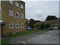
10
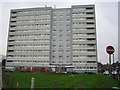
East Acton: Burghley Tower
A high rise block of flats on the west side of Old Oak Road.
Image: © Nigel Cox
Taken: 9 Feb 2007
0.10 miles