IMAGES TAKEN NEAR TO
Cezanne Road, LONDON, W3 7ET
Introduction
This page details the photographs taken nearby to Cezanne Road, W3 7ET by members of the Geograph project.
The Geograph project started in 2005 with the aim of publishing, organising and preserving representative images for every square kilometre of Great Britain, Ireland and the Isle of Man.

There are currently over 7.5m images from over14,400 individuals and you can help contribute to the project by visiting https://www.geograph.org.uk
Image Map
Images are licensed for reuse under creativecommons.org/licenses/by-sa/2.0
Notes
- Clicking on the map will re-center to the selected point.
- The higher the marker number, the further away the image location is from the centre of the postcode.
Image Listing (85 Images Found)
Images are licensed for reuse under creativecommons.org/licenses/by-sa/2.0
Image
Details
Distance
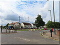
3
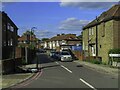
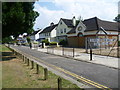
Manet Gardens, Cezanne Road, Western Circus Acton
The houses on the right are on new roads set back from the Western Avenue A40 dual carriageway, built after a road scheme was abandoned. They are Manet Gardens (nearer) and Cezanne Road. They are mainly small blocks of flats. The taller buildings on the left are Western Circus, a group of blocks of flats on the site of a do-it-yourself store. There is a 2-way cycle track on the right between the houses and the dual carriageway. Bus stops on left and right have lay-bys so the stopped bus does not block the traffic lane.
Image: © David Hawgood
Taken: 29 Aug 2022
0.06 miles
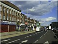
4
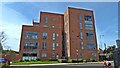
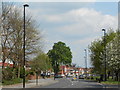
Bowes Road East Acton, view to Western Circus
View along Bowes Road to Glendun Road, new apartment block Western Circus is seen beyond.
Image: © David Hawgood
Taken: 29 Aug 2022
0.06 miles
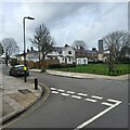
5
East Acton Lane and Glendun Road roundabout
View from Glendun Road to houses on corner.
Image: © David Hawgood
Taken: 29 Aug 2022
0.11 miles
7
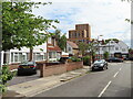
East Acton - Golf Links housing estate
Brassie Avenue and St Andrew's Road crossroad.
The estate was built in the 1920's on a golf course.
Image: © James Emmans
Taken: 12 Mar 2023
0.12 miles
8
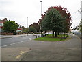
East Acton: East Acton Lane
The island of grass between the main East Acton Lane to the left and the access road to the right is a remnant of the time when East Acton was a separate village with a village green running through its entire length. This village green seems to have been developed in the 1850s and 1860s, as the 1850 Ordnance Survey map does not show it but the 1871 edition does. It extended from here at its western end right along to the surviving terrace of old houses south of Savoy Circus in what was then called Orchard Place.
Image: © Nigel Cox
Taken: 13 Oct 2010
0.12 miles
9
View from green next to East Acton Lane
The modern church on the right is the London Network Church. The main part of East Acton Lane is to the left, on the other side of the green.
Image: © Marathon
Taken: 23 Jul 2014
0.12 miles
10
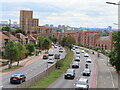
East Acton Lane, with Trellick Tower in distance
Image: © Andrew Wilson
Taken: 6 May 2013
0.13 miles