IMAGES TAKEN NEAR TO
Bowes Road, LONDON, W3 7AA
Introduction
This page details the photographs taken nearby to Bowes Road, W3 7AA by members of the Geograph project.
The Geograph project started in 2005 with the aim of publishing, organising and preserving representative images for every square kilometre of Great Britain, Ireland and the Isle of Man.

There are currently over 7.5m images from over14,400 individuals and you can help contribute to the project by visiting https://www.geograph.org.uk
Image Map
Images are licensed for reuse under creativecommons.org/licenses/by-sa/2.0
Notes
- Clicking on the map will re-center to the selected point.
- The higher the marker number, the further away the image location is from the centre of the postcode.
Image Listing (48 Images Found)
Images are licensed for reuse under creativecommons.org/licenses/by-sa/2.0
Image
Details
Distance
2
East Acton: Barbara Speake Stage School
Barbara Speake first opened a dancing school here, in St Dunstan's Hall in East Acton Lane, in 1945, so she currently has had a presence on the site for 65 years! For full information about the school please refer to its website here http://www.barbaraspeake.com/index.html . In 2007 Barbara Speake was awarded the MBE for services to drama in London.
A look at old Victorian Ordnance Survey maps shows that the site of the hall was once the terminus of a very short lived branch line railway line that curved away south-eastwards from the Great Western Railway main line from somewhere near where the A40 Western Avenue crosses it now. From maps that are currently available on line the railway was not there in 1874, but by 1896 it was, but was already described as "abandoned". Not a trace of the railway seems to exist today.
Image: © Nigel Cox
Taken: 13 Oct 2010
0.07 miles
3
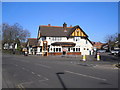
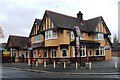
Acton: The 'Goldsmith's Arms'
A large public house at the junction of Friar's Place Lane (ahead to the left) and East Acton Lane.
Image: © Dr Neil Clifton
Taken: 18 Feb 2015
0.07 miles
4
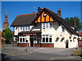
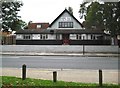
The Goldsmith's Arms in East Acton
In the background is the spire of St Dunstan's church Image
Image: © Rod Allday
Taken: 18 Aug 2012
0.07 miles
5
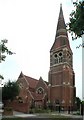
St Dunstan & St Thomas, Friars Place Lane, Acton
Image: © John Salmon
Taken: 3 Aug 2004
0.09 miles
6
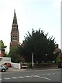
St Dunstan & St Thomas, Friars Place Lane, Acton
Image: © John Salmon
Taken: 3 Aug 2004
0.09 miles
7
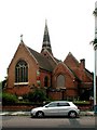
St Dunstan & St Thomas, Friars Place Lane, Acton
Image: © John Salmon
Taken: 3 Aug 2004
0.09 miles
8
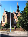
St Dunstan's Church
In the Parish of St Dunstan with St Thomas in East Acton.
Image: © Rod Allday
Taken: 18 Aug 2012
0.09 miles
9
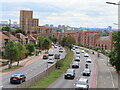
Manet Gardens, Cezanne Road, Western Circus Acton
The houses on the right are on new roads set back from the Western Avenue A40 dual carriageway, built after a road scheme was abandoned. They are Manet Gardens (nearer) and Cezanne Road. They are mainly small blocks of flats. The taller buildings on the left are Western Circus, a group of blocks of flats on the site of a do-it-yourself store. There is a 2-way cycle track on the right between the houses and the dual carriageway. Bus stops on left and right have lay-bys so the stopped bus does not block the traffic lane.
Image: © David Hawgood
Taken: 29 Aug 2022
0.09 miles
10
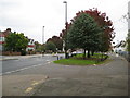
East Acton: East Acton Lane
The island of grass between the main East Acton Lane to the left and the access road to the right is a remnant of the time when East Acton was a separate village with a village green running through its entire length. This village green seems to have been developed in the 1850s and 1860s, as the 1850 Ordnance Survey map does not show it but the 1871 edition does. It extended from here at its western end right along to the surviving terrace of old houses south of Savoy Circus in what was then called Orchard Place.
Image: © Nigel Cox
Taken: 13 Oct 2010
0.10 miles