IMAGES TAKEN NEAR TO
Baldwyn Gardens, LONDON, W3 6HH
Introduction
This page details the photographs taken nearby to Baldwyn Gardens, W3 6HH by members of the Geograph project.
The Geograph project started in 2005 with the aim of publishing, organising and preserving representative images for every square kilometre of Great Britain, Ireland and the Isle of Man.

There are currently over 7.5m images from over14,400 individuals and you can help contribute to the project by visiting https://www.geograph.org.uk
Image Map
Images are licensed for reuse under creativecommons.org/licenses/by-sa/2.0
Notes
- Clicking on the map will re-center to the selected point.
- The higher the marker number, the further away the image location is from the centre of the postcode.
Image Listing (50 Images Found)
Images are licensed for reuse under creativecommons.org/licenses/by-sa/2.0
Image
Details
Distance
1

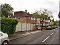
Acton Low Traffic Neighbourhood, Crane Avenue closure
The area behind the photographer is open to traffic from Horn Lane and Western Avenue, that in front from Horn Lane only.
Image: © David Hawgood
Taken: 18 Jan 2021
0.03 miles
2
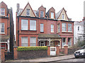
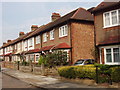
Victorian houses in Baldwyn Gardens, Acton, W3
These houses were completed c.1900.
Image: © MrC
Taken: 26 Feb 2009
0.03 miles
3
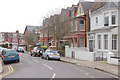
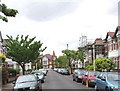
Baldwyn Gardens, Acton, W3
An early Edwardian development.
Image: © MrC
Taken: 26 Feb 2009
0.04 miles
4
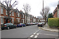
Junction of Grafton Road and Baldwyn Gardens, Acton, W3
View facing Grafton Road.
Image: © MrC
Taken: 3 Mar 2009
0.05 miles
5
Junction of Grasmere Avenue and Messaline Avenue, Acton, W3
View facing Grasmere Avenue.
Image: © MrC
Taken: 3 Mar 2009
0.08 miles
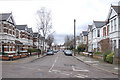
6
Faraday Road, Acton
View from Allison Road of the south side of Faraday Road
Image: © David Hawgood
Taken: 20 May 2006
0.13 miles
7

Semi-detached houses, Messaline Avenue, Acton
The houses are in pairs with narrow alleyways from street to back gardens. This style of house was built in the 1920s and 1930s. Streets often have a mixture of terraced and semi-detached houses built at the same period.
Image: © David Hawgood
Taken: 15 Sep 2006
0.13 miles
8
Terraced houses, Eastbourne Avenue, Acton
These were probably built in the 1920s or 1930s.
Image: © David Hawgood
Taken: 15 Sep 2006
0.14 miles
9
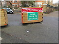
Acton Low Traffic Neighbourhood, Acacia Road closure
The area behind the photographer is accessible from Churchfield Road, that in front from Horn Lane. The signs here are more friendly than at other closures, the sign show the road open to pedestrians, unpowered scooters, wheel chairs and bicycles. It also shows camera enforcement which will have automatic number plate recognition (ANPR).
Image: © David Hawgood
Taken: 18 Jan 2021
0.14 miles
10
Westbourne Avenue, Acton
View along the road with Emmanuel Avenue at the end.
Image: © David Hawgood
Taken: 20 May 2006
0.15 miles