IMAGES TAKEN NEAR TO
Cumberland Road, LONDON, W3 6EX
Introduction
This page details the photographs taken nearby to Cumberland Road, W3 6EX by members of the Geograph project.
The Geograph project started in 2005 with the aim of publishing, organising and preserving representative images for every square kilometre of Great Britain, Ireland and the Isle of Man.

There are currently over 7.5m images from over14,400 individuals and you can help contribute to the project by visiting https://www.geograph.org.uk
Image Map
Images are licensed for reuse under creativecommons.org/licenses/by-sa/2.0
Notes
- Clicking on the map will re-center to the selected point.
- The higher the marker number, the further away the image location is from the centre of the postcode.
Image Listing (34 Images Found)
Images are licensed for reuse under creativecommons.org/licenses/by-sa/2.0
Image
Details
Distance
1
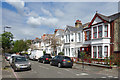
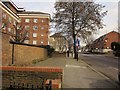
Summerlands Avenue, Acton
Housing of a similar age and style is found all over this area.
Image: © Des Blenkinsopp
Taken: 13 Apr 2017
0.07 miles
2
Nemoure Road, Acton
Seen across the A4000 Horn Lane. The road is a cul-de-sac.
Image: © Derek Harper
Taken: 21 Mar 2013
0.10 miles
3
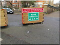
Acton Low Traffic Neighbourhood, Acacia Road closure
The area behind the photographer is accessible from Churchfield Road, that in front from Horn Lane. The signs here are more friendly than at other closures, the sign show the road open to pedestrians, unpowered scooters, wheel chairs and bicycles. It also shows camera enforcement which will have automatic number plate recognition (ANPR).
Image: © David Hawgood
Taken: 18 Jan 2021
0.12 miles
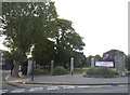
4
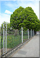
Park Railings, Springfield Gardens
This is the park boundary beside Horn Lane. The Gardens were opened in 1934 and these period railings are lucky to have survived the WW2 scrap metal raids that came a few years later.
Image: © Des Blenkinsopp
Taken: 13 Apr 2017
0.14 miles
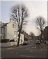
5
Horn Lane, Acton
The A4000. On the right is the junction with Acacia Road. On the left is Shalimar Lodge.
Image: © Derek Harper
Taken: 21 Mar 2013
0.15 miles
6
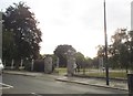
The entrance to Springfield Gardens on Horn Lane
Image: © David Howard
Taken: 27 Jun 2015
0.15 miles
7

Acton Low Traffic Neighbourhood, Crane Avenue closure
The area behind the photographer is open to traffic from Horn Lane and Western Avenue, that in front from Horn Lane only.
Image: © David Hawgood
Taken: 18 Jan 2021
0.17 miles

9
The entrance to Springfield Gardens on Horn Lane
Image: © David Howard
Taken: 27 Jun 2015
0.18 miles
10
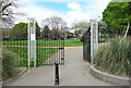
Gates into Springfield Gardens
A small park beside Horn Lane, created from wasteland in 1934 with an open-air theatre, which was subsequently pulled down. The gardens are called Springfield after the spring in Rosemont Road, on the west side of the park, which flows into Stamford Brook.
Image: © Des Blenkinsopp
Taken: 13 Apr 2017
0.19 miles