IMAGES TAKEN NEAR TO
The Drive, LONDON, W3 6AG
Introduction
This page details the photographs taken nearby to The Drive, W3 6AG by members of the Geograph project.
The Geograph project started in 2005 with the aim of publishing, organising and preserving representative images for every square kilometre of Great Britain, Ireland and the Isle of Man.

There are currently over 7.5m images from over14,400 individuals and you can help contribute to the project by visiting https://www.geograph.org.uk
Image Map
Images are licensed for reuse under creativecommons.org/licenses/by-sa/2.0
Notes
- Clicking on the map will re-center to the selected point.
- The higher the marker number, the further away the image location is from the centre of the postcode.
Image Listing (162 Images Found)
Images are licensed for reuse under creativecommons.org/licenses/by-sa/2.0
Image
Details
Distance
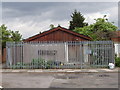
1
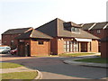
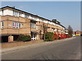
Friary Park Community Centre, Acton
View south from Joseph Avenue. This housing estate is on the site of Walls meat factories. The Victoria County History for Middlesex article on 'Acton: Economic history' http://www.british-history.ac.uk/report.asp?compid=22549#s4 tells us: " Walls bought the 6-a. site of Friars Place house and grounds in 1919 and built a factory there to make sausages, pies, and brawn, with a slaughterhouse in Warple Way to which pigs were driven from the G.W.R. line" and "From 1956 the Friary factory concentrated on ice cream, all the meat business moving to Atlas Road, and in 1958 the two factories together employed over 3,000, with 514 at Atlas Road in 1964. The Atlas Road factory was closed c. 1978 and the Friary factory employed 800 in 1980."
Image: © David Hawgood
Taken: 15 Mar 2006
0.04 miles
2
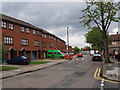
Modern houses in Emmanuel Avenue, Acton
These houses on the left were built when the Walls factory closed. View from the end of Westbourne Avenue.
Image: © David Hawgood
Taken: 20 May 2006
0.05 miles
3
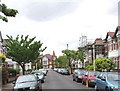
Westbourne Avenue, Acton
View along the road with Emmanuel Avenue at the end.
Image: © David Hawgood
Taken: 20 May 2006
0.07 miles
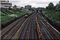
4
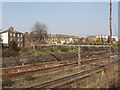
Railway at Acton, with York Road beyond
The main line railway from Paddington to the west, view north from Friary Road near Acton Mainline Station. Beyond are the back of houses in York Road.
Image: © David Hawgood
Taken: 15 Mar 2006
0.07 miles
5
Scout hut, Eastbourne Avenue, Acton
Hut at the corner of Emmanuel and Eastbourne Avenues. It is surrounded by a substantial security fence.
Image: © David Hawgood
Taken: 20 May 2006
0.08 miles
6
Paddington Bound
Class 50, 50041 'Bulwark', passes through Acton on its way into London Paddington. Through the arches of the bridge carrying Horn Lane, the platforms of Acton Main Line station are visible. the tracks on the right of the photo lead up to Acton Wells Junction and a connection with the North London Line. On the left of the photo is the Walls Ice Cream factory which closed in the late 1980's and was replaced by a housing estate.
Image: © Martin Addison
Taken: Unknown
0.08 miles
7
Emanuel Avenue with bicycle contra-flow track.
The western section of Emanuel Avenue is a one way street for motor vehicles, but has a cycle lane the other way. The bollard has a bike symbol, the cycle track surface is coloured green with a bike symbol on it.
Image: © David Hawgood
Taken: 15 Sep 2006
0.08 miles
9
Terrace houses on Friary Road, North Acton
View north-east across Friary Road from the end of Joseph Avenue.
Image: © David Hawgood
Taken: 15 Mar 2006
0.08 miles
10
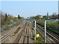
Great Western main line
Looking towards Paddington from the Horn Lane bridge. The overhead wires are only used by the Heathrow services so far.
Image: © Robin Webster
Taken: 27 Mar 2011
0.08 miles