IMAGES TAKEN NEAR TO
Queens Drive, LONDON, W3 0HZ
Introduction
This page details the photographs taken nearby to Queens Drive, W3 0HZ by members of the Geograph project.
The Geograph project started in 2005 with the aim of publishing, organising and preserving representative images for every square kilometre of Great Britain, Ireland and the Isle of Man.

There are currently over 7.5m images from over14,400 individuals and you can help contribute to the project by visiting https://www.geograph.org.uk
Image Map
Images are licensed for reuse under creativecommons.org/licenses/by-sa/2.0
Notes
- Clicking on the map will re-center to the selected point.
- The higher the marker number, the further away the image location is from the centre of the postcode.
Image Listing (130 Images Found)
Images are licensed for reuse under creativecommons.org/licenses/by-sa/2.0
Image
Details
Distance
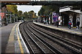
1
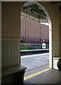
North Ealing station: view from the passenger shelter
Image: © Stefan Czapski
Taken: 5 May 2022
0.01 miles
2
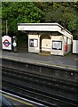
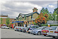
North Ealing station: passenger shelter on the London-bound platform
This must have survived from the days of the Metropolitan District Railway, circa 1900. To me, it seems oddly stylish for a humble railway building - I can almost imagine it by the Derby course on Epsom Downs, or by an Indian polo pitch in the days of the Raj.
The entire station - I have since learnt - is a listed building.
Image: © Stefan Czapski
Taken: 5 May 2022
0.01 miles
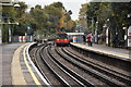
3
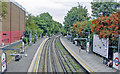
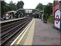
North Ealing station
View NE, towards Rayners Lane and Uxbridge: London Underground Piccadilly Line, originally Metropolitan-District Railway. (See also Image]).
Image: © Ben Brooksbank
Taken: 18 Aug 2009
0.02 miles
4
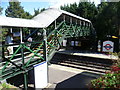
The footbridge at North Ealing station
North Ealing station was opened on 23rd June 1903 by the District Railway on its new extension from north of Ealing Common to Park Royal & Twyford Abbey. The line was opened fully to South Harrow on 28th June 1903.
This new extension was, together with the existing tracks between Ealing Common and Acton Town, the first section of the Underground's surface lines to be electrified and operate electric instead of steam trains.
On 4th July 1932 the Piccadilly line was extended to run west of its original terminus at Hammersmith sharing the route with the District line to Ealing Common. From Ealing Common to South Harrow, the District line was replaced by the Piccadilly line on this date.
This view is of the footbridge which leads from the entrance to the down platform. See also http://www.geograph.org.uk/photo/4121796 and http://www.geograph.org.uk/photo/4122033
Image: © Marathon
Taken: 13 Aug 2014
0.02 miles
7
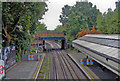
North Ealing station, 2009
View south, towards Acton Town, Central London, Piccadilly Circus, King's Cross, Finsbury Park and Cockfosters, London Underground Piccadilly Line.
Image: © Ben Brooksbank
Taken: 18 Aug 2009
0.02 miles
8
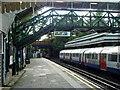
On North Ealing station
On the Piccadilly Line, Uxbridge branch. A westbound train of 1972 tube stock is at the platform.
Image: © Robin Webster
Taken: 6 Oct 2012
0.02 miles
9
North Ealing Underground station, Greater London
Opened in 1903 by the Metropolitan District Railway on the line from Central London via Turnham Green to South Harrow.
View south west towards Ealing Common and central London. Unlike most other underground stations near here, it was not rebuilt in the 1930s and not renamed. But like 55% of the London Underground network, this part is actually overground.
Image: © Nigel Thompson
Taken: 31 Jul 2018
0.02 miles
10
North Ealing station, entrance Down side
View northward, towards Rayners Lane and Uxbridge: London Underground Piccadilly Line, from Acton Town, Hammersmith, Piccadilly Circus and Cockfosters.
Image: © Ben Brooksbank
Taken: 18 Aug 2009
0.02 miles