IMAGES TAKEN NEAR TO
Harrow Road, LONDON, W2 6NL
Introduction
This page details the photographs taken nearby to Harrow Road, W2 6NL by members of the Geograph project.
The Geograph project started in 2005 with the aim of publishing, organising and preserving representative images for every square kilometre of Great Britain, Ireland and the Isle of Man.

There are currently over 7.5m images from over14,400 individuals and you can help contribute to the project by visiting https://www.geograph.org.uk
Image Map
Images are licensed for reuse under creativecommons.org/licenses/by-sa/2.0
Notes
- Clicking on the map will re-center to the selected point.
- The higher the marker number, the further away the image location is from the centre of the postcode.
Image Listing (786 Images Found)
Images are licensed for reuse under creativecommons.org/licenses/by-sa/2.0
Image
Details
Distance
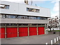
1
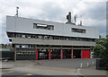
Paddington Fire Station, Harrow Road
Probably dating from the 1960s or 1970s.
Image: © Stephen Richards
Taken: 3 Jul 2011
0.01 miles
2
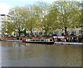
Little Venice waterbus, London
Viewed from Westbourne Terrace Road Bridge. http://www.geograph.org.uk/photo/3136858
This triangular shaped area between the Grand Union Canal (Paddington Branch) and Regents Canal is known as Little Venice. The waterbus, named Perseus, is a passenger launch with a capacity for 68 passengers. She is one of four London Waterbus Company vessels operating a service on the Regents Canal from Little Venice to London Zoo and Camden Lock with occasional trips to Limehouse, the River Lea and Brentford. She was built in 1935 as a cargo-carrying vessel and was formerly part of the British Transport Waterways fleet.
Image: © Jaggery
Taken: 13 May 2012
0.02 miles
3
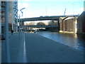
Sheldon Square W2
This is the path along the Paddington Branch of the Grand Union Canal. The road bridge carries the busy A40 Westway. The other bridge is a footbridge. Little Venice is a short walk from here in the direction of shot.
Image: © Danny P Robinson
Taken: 5 Mar 2006
0.03 miles
4
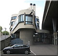
Battleship Building, Paddington Central
View of "prow" from car park below Westway when building was in "Open House London".
Image: © David Hawgood
Taken: 17 Sep 2011
0.04 miles
5
Paddington Fire Station
View from Harrow road.
Image: © David Hawgood
Taken: 26 Feb 2007
0.04 miles
6
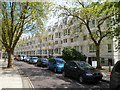
Warwick Crescent London W2
The major building in Warwick Crescent is a 115 metre long five storey row of about 60 flats on the south side of the area of water between the Grand Union Canal (Paddington Branch) and Regents Canal known as Little Venice.
Image: © Jaggery
Taken: 13 May 2012
0.04 miles
7
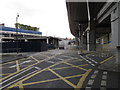
Slip road and roundabout for Paddington Central
The roads here are in three layers. Top is the Westway, A40 elevated carriageway. Middle is the Harrow Road A404 Westbound. Bottom are service roads of Paddington Central and Paddington Basin. This photo taken from under Westway by the Battleship Building show the slip road up from a roundabout at bottom level to the middle level.
Image: © David Hawgood
Taken: 17 Sep 2011
0.04 miles
8
View of spotlights illuminating the wall beside Warwick Crescent
Looking north-northwest.
Image: © Robert Lamb
Taken: 6 Apr 2018
0.05 miles
9
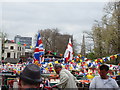
View of St Mary Magdalene Church on Rowington Close and Princethorpe and Wilmcote Houses on Woodchester Square above the flags
Looking north-northwest.
Image: © Robert Lamb
Taken: 5 May 2013
0.05 miles
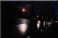
10
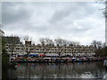
View of narrowboats moored up at Little Venice for the Canal Cavalcade #8
Looking southeast, against the backdrop of the apartments on Warwick Crescent.
Image: © Robert Lamb
Taken: 5 May 2013
0.05 miles