IMAGES TAKEN NEAR TO
Blomfield Villas, LONDON, W2 6NH
Introduction
This page details the photographs taken nearby to Blomfield Villas, W2 6NH by members of the Geograph project.
The Geograph project started in 2005 with the aim of publishing, organising and preserving representative images for every square kilometre of Great Britain, Ireland and the Isle of Man.

There are currently over 7.5m images from over14,400 individuals and you can help contribute to the project by visiting https://www.geograph.org.uk
Image Map
Images are licensed for reuse under creativecommons.org/licenses/by-sa/2.0
Notes
- Clicking on the map will re-center to the selected point.
- The higher the marker number, the further away the image location is from the centre of the postcode.
Image Listing (682 Images Found)
Images are licensed for reuse under creativecommons.org/licenses/by-sa/2.0
Image
Details
Distance
1
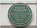
Slow, slow, quick, quick, slower (89)
Green plaque in Westbourne Terrace Road: for more see https://en.wikipedia.org/wiki/Margery_Allingham
Image: © Basher Eyre
Taken: 23 Apr 2016
0.03 miles
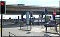
2
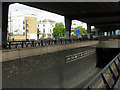
Under Westway
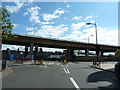
Westway is the name given to the A40 route out of London. Between Paddington and Westbourne Park it runs parallel to the Great Western main line along an elevated section. The area is a confusing mass of flyovers and underpasses.
Image: © Stephen McKay
Taken: 31 Aug 2007
0.03 miles
3
Slow, slow, quick, quick, slower (86)
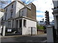
Traffic lights in Westbourne Terrace Road
Image: © Basher Eyre
Taken: 23 Apr 2016
0.04 miles
4
Slow, slow, quick, quick, slower (88)
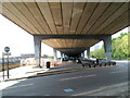
Looking westwards at the Westway (northern side of Westbourne Bridge)
Image: © Basher Eyre
Taken: 23 Apr 2016
0.04 miles
5
Slow, slow, quick, quick, slower (90)
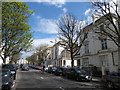
Westbourne Terrace Road
Image: © Basher Eyre
Taken: 23 Apr 2016
0.04 miles
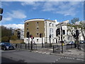
6
Approaching Harrow Road from Westbourne Terrace Road, Paddington
With Westway above
Image: © Alexander P Kapp
Taken: 19 Jul 2012
0.04 miles
7
Slow, slow, quick, quick, slower (91)
Blomfield Mews
Image: © Basher Eyre
Taken: 23 Apr 2016
0.04 miles
8
Under Westway, London
Westway is a 3.5-mile (5.6 km) long elevated dual carriageway section of the A40 in west London from Paddington to North Kensington. This section is immediately south of Westbourne Terrace Road.
Image: © Jaggery
Taken: 13 May 2012
0.05 miles
9

Slow, slow, quick, quick, slower (92)
Delamere Street
Image: © Basher Eyre
Taken: 23 Apr 2016
0.05 miles
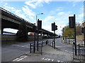
10
Westway and Harrow Road, London
Viewed from Westbourne Terrace Road. http://www.geograph.org.uk/photo/3137135 Westway is the elevated road, above Harrow Road.
Image: © Jaggery
Taken: 13 May 2012
0.05 miles