IMAGES TAKEN NEAR TO
Woodchester Square, LONDON, W2 5ST
Introduction
This page details the photographs taken nearby to Woodchester Square, W2 5ST by members of the Geograph project.
The Geograph project started in 2005 with the aim of publishing, organising and preserving representative images for every square kilometre of Great Britain, Ireland and the Isle of Man.

There are currently over 7.5m images from over14,400 individuals and you can help contribute to the project by visiting https://www.geograph.org.uk
Image Map
Images are licensed for reuse under creativecommons.org/licenses/by-sa/2.0
Notes
- Clicking on the map will re-center to the selected point.
- The higher the marker number, the further away the image location is from the centre of the postcode.
Image Listing (275 Images Found)
Images are licensed for reuse under creativecommons.org/licenses/by-sa/2.0
Image
Details
Distance
1
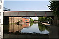
Enclosed bridge, Paddington Arm, Grand Union Canal
This enclosed, and therefore presumably private, bridge is just a few yards east of Harrow Road Bridge 3, see Image
Image: © Dr Neil Clifton
Taken: 8 May 2008
0.02 miles
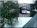
2
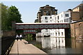
Enclosed bridge and Harrow Road Bridge 3, Paddington Arm, Grand Union Canal
Looking west, this shows these two bridges in relationship to each other. The photograph is also taken just opposite to the mural, made from rubbish.
Image: © Dr Neil Clifton
Taken: 8 May 2008
0.02 miles
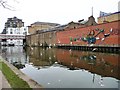
3
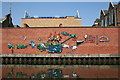
Mural alongside the Paddington Arm, Grand Union Canal
This mural was constructed from rubbish found in or around the canal, by members of a nearby youth club.
Image: © Dr Neil Clifton
Taken: 8 May 2008
0.02 miles
4
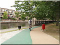
New cycle path past the Warwick estate, Paddington
The green strip is a cycle path alongside the Grand Union Canal. When the photo was taken it had just been laid and not all of it was finished.
Image: © David Hawgood
Taken: 23 Aug 2008
0.02 miles
5
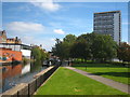
Westbourne Green Open Space
This open space dates from about 1974, when the area it now covers was the site compound for the construction of the A40 Westway and the Marylebone Flyover. Once these works were complete the area was laid out as a new public open space. On the left of the photo, across the canal, can be seen Image and ahead is Image
Image: © Rod Allday
Taken: 3 Sep 2011
0.02 miles
6
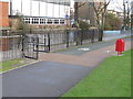
Paddington Arm - Westbourne Green towpath access
At this point cyclists have to leave the towpath and use the cycle track inside Westbourne Green. The towpath surface is of paving slabs, the paths in Westbourne Green are tarmac, coloured green for the cycle track.
Image: © David Hawgood
Taken: 15 Dec 2011
0.03 miles
7
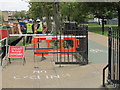
"Cyclists please dismount" in nonsense place
These workmen are relaying paving on a section of towpath which is clearly marked as "No cycling", and they have completely blocked the towpath with a barrier. Cyclists can legally go past onto a cycle path parallel to the towpath, and while the work is in progress pedestrians have to go onto the parallel path. Thus having a sign "Cyclists please dismount" is a complete nonsense, and is the sort of thing that leads cyclists to ignore all such signs.
Image: © David Hawgood
Taken: 10 Oct 2011
0.03 miles
8
Grand Union Canal - Paddington Branch
Looking toward Harrow Road
Image: © PAUL FARMER
Taken: 5 May 2012
0.03 miles
9
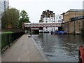
Harrow Road bridge, W2
Crossing the Grand Union Canal at Harrow Road.
Image: © Phillip Perry
Taken: 5 Feb 2007
0.03 miles
10
Swirling seagulls above the Paddington Branch
The mural across the canal was made from litter by Kevin Herlihy and the Stowe Youth Club.
Image: © Christine Johnstone
Taken: 28 Feb 2012
0.03 miles