IMAGES TAKEN NEAR TO
Westbourne Park Road, LONDON, W2 5PH
Introduction
This page details the photographs taken nearby to Westbourne Park Road, W2 5PH by members of the Geograph project.
The Geograph project started in 2005 with the aim of publishing, organising and preserving representative images for every square kilometre of Great Britain, Ireland and the Isle of Man.

There are currently over 7.5m images from over14,400 individuals and you can help contribute to the project by visiting https://www.geograph.org.uk
Image Map
Images are licensed for reuse under creativecommons.org/licenses/by-sa/2.0
Notes
- Clicking on the map will re-center to the selected point.
- The higher the marker number, the further away the image location is from the centre of the postcode.
Image Listing (225 Images Found)
Images are licensed for reuse under creativecommons.org/licenses/by-sa/2.0
Image
Details
Distance
1
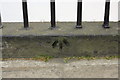
Benchmark on wall of #31 Westbourne Park Road
Ordnance Survey cut mark benchmark described on the Bench Mark Database at http://www.bench-marks.org.uk/bm37940
Image: © Roger Templeman
Taken: 13 May 2011
0.02 miles
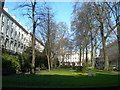
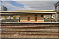
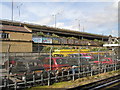
3
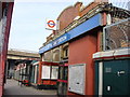
Royal Oak Tube
Royal Oak Tube Station on the Hammersmith and City line
Image: © Oxyman
Taken: 12 Mar 2007
0.05 miles

5
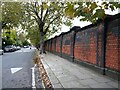
Brick wall, Westbourne Park Villas
The south side of the street is residential, while this wall runs along the north side, separating the street system from the main rail route out of Paddington. I didn't look, but just over the wall there must be a sharp drop into the railway cutting.
What grabbed my attention was the way the wall seems to lean back from the pavement - in technical terms the wall is 'battered'. While most of the brickwork is red, use has also been made of black 'engineering' brick (extra tough, typically found in railway and canal bridges). Black brick is used for the rounded corners of the uprights (piers).
My first thought was that the style of building showed the influence of the Arts and Crafts movement. You can find rounded corners at the Horniman Museum, for instance. But that would date the wall to about 1900 - and the railway arrived in Paddington in 1837. If the wall dates from not long after, could it be that we're looking at a product of the mid-century craze for all things Egyptian?
Image: © Stefan Czapski
Taken: 30 Oct 2021
0.05 miles
8
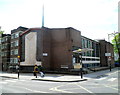
Westbourne Park Baptist Church, London W2
The church is on the corner of Porchester Road and Westbourne Park Villas,
near the southern end of Lord Hills Bridge. http://www.geograph.org.uk/photo/3137452
Image: © Jaggery
Taken: 13 May 2012
0.07 miles
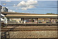
10
A40 'Westway' London W2
Picture taken from Royal Oak Hammersmith & City underground station.
Image: © Chris McMillan
Taken: 24 May 2005
0.08 miles