IMAGES TAKEN NEAR TO
Star Street, LONDON, W2 1QA
Introduction
This page details the photographs taken nearby to Star Street, W2 1QA by members of the Geograph project.
The Geograph project started in 2005 with the aim of publishing, organising and preserving representative images for every square kilometre of Great Britain, Ireland and the Isle of Man.

There are currently over 7.5m images from over14,400 individuals and you can help contribute to the project by visiting https://www.geograph.org.uk
Image Map
Images are licensed for reuse under creativecommons.org/licenses/by-sa/2.0
Notes
- Clicking on the map will re-center to the selected point.
- The higher the marker number, the further away the image location is from the centre of the postcode.
Image Listing (1231 Images Found)
Images are licensed for reuse under creativecommons.org/licenses/by-sa/2.0
Image
Details
Distance
1
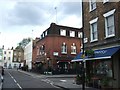
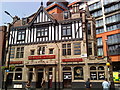
The Sir Alexander Fleming
The inn is named after the discoverer of penicillin; he worked in the hospital close by.
Image: © David Smith
Taken: 11 May 2010
0.02 miles
2
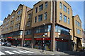
Frontline Restaurant, Norfolk Place, London
Image: © PAUL FARMER
Taken: 19 Aug 2013
0.03 miles
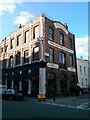
7
Rob Roy pub, Paddington
On the corner of Sale Place and Star Street.
The pub's website describes the Rob Roy as "the only genuine Scottish pub in central London".
Image: © Jaggery
Taken: 12 May 2012
0.04 miles
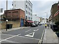
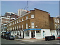
9
St Michael's Street, Paddington
A view to the NE from the corner of Bouverie Place, near the Sir Alexander Fleming pub. http://www.geograph.org.uk/photo/2943215
Image: © Jaggery
Taken: 12 May 2012
0.04 miles
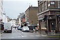
10
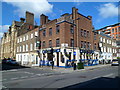
Cheminee Persian Restaurant, Paddington
On the corner of Bouverie Place and St Michael's Street, City of Westminster, London W2.
There is a low wall and gap in the buildings on the right, behind the lorry. London Underground's railway lines are near road level here, between Paddington station and Edgware Road station.
Image: © Jaggery
Taken: 12 May 2012
0.04 miles