IMAGES TAKEN NEAR TO
Hall Place, LONDON, W2 1LL
Introduction
This page details the photographs taken nearby to Hall Place, W2 1LL by members of the Geograph project.
The Geograph project started in 2005 with the aim of publishing, organising and preserving representative images for every square kilometre of Great Britain, Ireland and the Isle of Man.

There are currently over 7.5m images from over14,400 individuals and you can help contribute to the project by visiting https://www.geograph.org.uk
Image Map
Images are licensed for reuse under creativecommons.org/licenses/by-sa/2.0
Notes
- Clicking on the map will re-center to the selected point.
- The higher the marker number, the further away the image location is from the centre of the postcode.
Image Listing (372 Images Found)
Images are licensed for reuse under creativecommons.org/licenses/by-sa/2.0
Image
Details
Distance

6
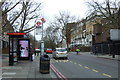
Bus stop and shelter on Edgware Road (A5)
Looking north west.
Image: © JThomas
Taken: 18 Mar 2017
0.05 miles
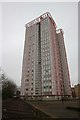
7
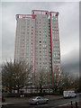
Parsons House
This block of flats is on the west side of Edgware Road. Click the link for more photos and details.
http://www.emporis.com/en/wm/bu/?id=136020
Image: © Danny P Robinson
Taken: 9 Apr 2006
0.05 miles
8
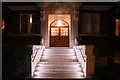
View of the steps of Aubrey House illuminated from Maida Avenue
Looking south-southeast.
Image: © Robert Lamb
Taken: 6 Apr 2018
0.05 miles
9
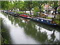
Regent's Canal in Maida Vale (3)
Viewed looking down from Maida Avenue, with Blomfield Road beyond.
Image: © Nigel Cox
Taken: 19 Aug 2007
0.05 miles
10
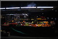
View of Jannat Supermarket from Edgware Road
Looking south-southwest.
Image: © Robert Lamb
Taken: 6 Apr 2018
0.05 miles