IMAGES TAKEN NEAR TO
Marchbank Road, LONDON, W14 9PL
Introduction
This page details the photographs taken nearby to Marchbank Road, W14 9PL by members of the Geograph project.
The Geograph project started in 2005 with the aim of publishing, organising and preserving representative images for every square kilometre of Great Britain, Ireland and the Isle of Man.

There are currently over 7.5m images from over14,400 individuals and you can help contribute to the project by visiting https://www.geograph.org.uk
Image Map
Images are licensed for reuse under creativecommons.org/licenses/by-sa/2.0
Notes
- Clicking on the map will re-center to the selected point.
- The higher the marker number, the further away the image location is from the centre of the postcode.
Image Listing (213 Images Found)
Images are licensed for reuse under creativecommons.org/licenses/by-sa/2.0
Image
Details
Distance
1
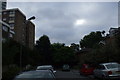
63 - 73 Marchbank Road, W14
You can just make out the houses on the right hand side, where the green car is, 6 houses obscured by trees, that are more correctly should be in Thaxton Road and not Marchbank. The houses and block of flats on the left are in Marchbank Road, and part of the notorious West Kensington estate.
Image: © Phillip Perry
Taken: 15 Aug 2009
0.01 miles
2
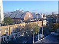
Lillie Road and Earls Court Exhibition Centre from Ibis Hotel
Image: © David Gearing
Taken: 15 Nov 2006
0.02 miles
3
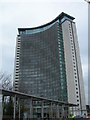
Empress State Building
This distinctive building is on Lillie Road, SW6. For more info, follow this link. http://www.skyscrapernews.com/buildings.php?id=80
Image: © Danny P Robinson
Taken: 11 Apr 2006
0.04 miles
4
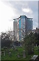
Empress State Building, Earl's Court
View from Brompton Cemetery. Built in the early 1960s to the designs of architects Stone Toms & Partners.
Image: © Jim Osley
Taken: 20 Nov 2015
0.04 miles
5
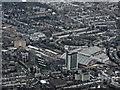
Earl's Court from the air
The Empress State Building and the exhibition centre, viewed from a Heathrow bound flight from Prague.
Image: © Thomas Nugent
Taken: 1 Apr 2015
0.04 miles
6
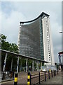
Empress State Building
Home to the Metropolitan Police
Image: © Mr Biz
Taken: 29 Apr 2014
0.04 miles
7
View of the Empress State Building behind the Earls Court Exhibition Centre from Earls Court Square
Looking south-southwest.
Image: © Robert Lamb
Taken: 14 Jun 2014
0.04 miles
8
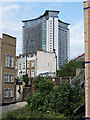
West Kensington Estate and Empress State Building
Local authority housing on the West Kensington Estate in West London. The Empress State Building towers over the estate.
The local authority has plans to regenerate the area, demolishing the estate so that a private developer can build new homes on the site.
Image: © Malc McDonald
Taken: 28 Jun 2011
0.05 miles
9
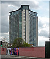
Empress State Building, Lillie Road
Y-shaped with concave sides. Built c1962 to the design of Stone, Toms & Partners, its 320 feet making it briefly London's tallest building. In c2003 it was increased by three floors, including a rooftop bar, Orbit, and the brise soleil was added to the south facade.
Currently occupied largely by the Metropolitan Police.
Image: © Stephen Richards
Taken: 30 Apr 2016
0.05 miles
10
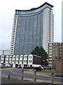
Empress State Building
Viewed from West Brompton railway station
Image: © Thomas Nugent
Taken: 5 Jun 2015
0.05 miles