IMAGES TAKEN NEAR TO
Beaumont Avenue, LONDON, W14 9LP
Introduction
This page details the photographs taken nearby to Beaumont Avenue, W14 9LP by members of the Geograph project.
The Geograph project started in 2005 with the aim of publishing, organising and preserving representative images for every square kilometre of Great Britain, Ireland and the Isle of Man.

There are currently over 7.5m images from over14,400 individuals and you can help contribute to the project by visiting https://www.geograph.org.uk
Image Map
Images are licensed for reuse under creativecommons.org/licenses/by-sa/2.0
Notes
- Clicking on the map will re-center to the selected point.
- The higher the marker number, the further away the image location is from the centre of the postcode.
Image Listing (249 Images Found)
Images are licensed for reuse under creativecommons.org/licenses/by-sa/2.0
Image
Details
Distance
1
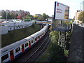
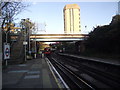
District Line, just east of West Kensington Station
A west-bound train is just entering the station, and an east-bound train is about to leave.
Image: © John Lord
Taken: 26 Oct 2009
0.03 miles
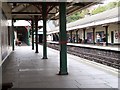
2
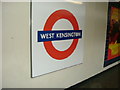
West Kensington Station, W14
West Kensington Station, North End Road, W14
Image: © Phillip Perry
Taken: 28 Apr 2007
0.03 miles
4
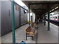
New benches at West Kensington Station
On west-bound platform only, so far at least.
Image: © John Lord
Taken: 13 Jul 2010
0.04 miles
5
Bridge over the District Line
To the east of West Kensington station
Image: © Tim Glover
Taken: 6 Nov 2017
0.04 miles
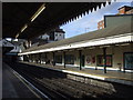
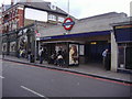
6
West Kensington Station
District Line
Image: © Russell Trebor
Taken: 28 Jul 2006
0.04 miles
7
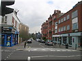
Beaumont Avenue W14
From junction with North End Road W14
Image: © Robin Sones
Taken: 31 Mar 2009
0.04 miles
9
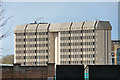
Ashfield House, West Cromwell Road
A fortress-like building, perhaps dating from the late 1970s.
Currently offices of Transport for London, its third floor intriguingly contains a fully mocked-up tube station, West Ashfield, used for staff training purposes.
A view from Lillie Road which has been opened up by the demolition of Earl's Court.
Image: © Stephen Richards
Taken: 30 Apr 2016
0.05 miles
10
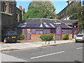
Citizen's Advice Bureau, Mund Street W14
Image: © Robin Sones
Taken: 26 Aug 2009
0.05 miles