IMAGES TAKEN NEAR TO
Sherwood Close, LONDON, W13 9YR
Introduction
This page details the photographs taken nearby to Sherwood Close, W13 9YR by members of the Geograph project.
The Geograph project started in 2005 with the aim of publishing, organising and preserving representative images for every square kilometre of Great Britain, Ireland and the Isle of Man.

There are currently over 7.5m images from over14,400 individuals and you can help contribute to the project by visiting https://www.geograph.org.uk
Image Map
Images are licensed for reuse under creativecommons.org/licenses/by-sa/2.0
Notes
- Clicking on the map will re-center to the selected point.
- The higher the marker number, the further away the image location is from the centre of the postcode.
Image Listing (106 Images Found)
Images are licensed for reuse under creativecommons.org/licenses/by-sa/2.0
Image
Details
Distance
2
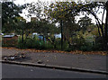
Doing the Crossword
An autumn afternoon in Dean Gardens, West Ealing.
Formerly allotments, this was made into a park in 1909.
Image: © Des Blenkinsopp
Taken: 27 Oct 2014
0.05 miles
5
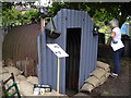
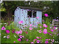
Restored Anderson Shelter in Northfield Allotments
Image: © Mark Percy
Taken: 15 Aug 2013
0.06 miles
6
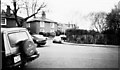
Mattock Lane, Ealing
Early Victorian Cottages, Mattock lane. The name "Mattock", may reflect the agricultural history of this area. Northfields allotments still exist within 50 metres of these cottages.
Also see http://www.geograph.org.uk/photo/684470
Image: © Tom Jolliffe
Taken: Unknown
0.06 miles
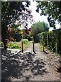
7

Deans Villas, Mattock lane, Ealing
Seen from St John's Church. Small semi-detached early Victorian cottages. Facing towards footpath to Northfields allotments.
Also see http://www.geograph.org.uk/photo/684470
Image: © Tom Jolliffe
Taken: Unknown
0.07 miles
8
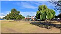
Path leaves the road
From Mattock Lane, Radbourne Walk a public footpath, runs past the Northfield Avenue Allotments to Glenfield Road.
The church of St John was built in 1875 in the Early English style in brick with stone dressings. Listed, grade II, with details at: https://historicengland.org.uk/listing/the-list/list-entry/1079389
Ealing is one of the seven major towns in the London Borough of Ealing. A rural village until communications with London got better with the improvements to the road to Oxford (later Uxbridge Road) in the 18th century and culminating with the coming of the railway in 1838. Ealing expanded greatly with suburban development during the 19th century and became known as the "Queen of the Suburbs" due to its greenery and because it was halfway between city and country. Ealing became a municipal borough in 1901. Growth continued throughout the 20th century and Ealing became part of a modern London borough in 1965.
Image: © Michael Dibb
Taken: 14 Sep 2019
0.07 miles
9

Land near St John's Church, Mattock lane
This piece of land used to be part of an allotment used by the residents at 65 Mattock Lane, Deans Villas at the cottages nearby. It is today part of a conservation area.
Image: © Tom Jolliffe
Taken: Unknown
0.07 miles
10
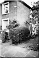
65 Mattock Lane, Deans Villas
65-70 Mattock Lane are three pairs of semi-detached Victorian cottages are constructed in stock brick with bold stucco trimming and have hipped slate roof. Early timber sashes with very fine glazing bars are still retained and add to the character of the architecture.
The tree which is touching the wall of this house was a mature tree in the 1950s and bore a prolific crop of pears each year. "Deans Villas" is inscribed on the small plaque which is inset into the house wall.
Image: © Tom Jolliffe
Taken: Unknown
0.08 miles