IMAGES TAKEN NEAR TO
Leyborne Avenue, LONDON, W13 9RA
Introduction
This page details the photographs taken nearby to Leyborne Avenue, W13 9RA by members of the Geograph project.
The Geograph project started in 2005 with the aim of publishing, organising and preserving representative images for every square kilometre of Great Britain, Ireland and the Isle of Man.

There are currently over 7.5m images from over14,400 individuals and you can help contribute to the project by visiting https://www.geograph.org.uk
Image Map
Images are licensed for reuse under creativecommons.org/licenses/by-sa/2.0
Notes
- Clicking on the map will re-center to the selected point.
- The higher the marker number, the further away the image location is from the centre of the postcode.
Image Listing (50 Images Found)
Images are licensed for reuse under creativecommons.org/licenses/by-sa/2.0
Image
Details
Distance
1
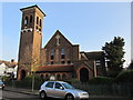
St Aidans Court, Northfields
A former church now converted into flats. A stone in the wall states 'To the Glory Of God. This Stone was Laid by Robert Whyte Esq. 17th June 1922'
Image: © Richard Rogerson
Taken: 18 Feb 2013
0.08 miles
3

Bean n Scone coffee cart, Lammas Park, Ealing
This cart was selling cream teas with a variety of different fruit scones, and a choice of jams.
Image: © David Hawgood
Taken: 25 Sep 2023
0.10 miles
4
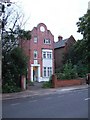
House in Elers Road
The house is dated 1898, and shows Dutch influence in the gable.
Image: © David Smith
Taken: 14 Jun 2011
0.12 miles
5
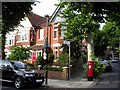
Junction of Lyncroft Road and Lavington Road, Ealing, W13
Upmarket Edwardian suburbia in Ealing.
Image: © Peter Jordan
Taken: 9 Sep 2006
0.12 miles
10
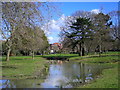
Drainage pond, Lammas Park
This seasonal drainage pond was dug in 2014 to contain flood water which regularly submerged the nearby footpath.
Image: © Mark Percy
Taken: 25 Mar 2016
0.14 miles