IMAGES TAKEN NEAR TO
Elers Road, LONDON, W13 9QA
Introduction
This page details the photographs taken nearby to Elers Road, W13 9QA by members of the Geograph project.
The Geograph project started in 2005 with the aim of publishing, organising and preserving representative images for every square kilometre of Great Britain, Ireland and the Isle of Man.

There are currently over 7.5m images from over14,400 individuals and you can help contribute to the project by visiting https://www.geograph.org.uk
Image Map
Images are licensed for reuse under creativecommons.org/licenses/by-sa/2.0
Notes
- Clicking on the map will re-center to the selected point.
- The higher the marker number, the further away the image location is from the centre of the postcode.
Image Listing (63 Images Found)
Images are licensed for reuse under creativecommons.org/licenses/by-sa/2.0
Image
Details
Distance
1
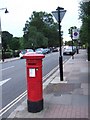
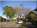
Elers Road
A Victorian pillarbox at the north end of Elers Road. On the left is Lammas Park
Image: © David Smith
Taken: 14 Jun 2011
0.02 miles
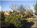

6
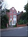
House in Elers Road
The house is dated 1898, and shows Dutch influence in the gable.
Image: © David Smith
Taken: 14 Jun 2011
0.06 miles
7
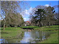
Drainage pond, Lammas Park
This seasonal drainage pond was dug in 2014 to contain flood water which regularly submerged the nearby footpath.
Image: © Mark Percy
Taken: 25 Mar 2016
0.06 miles
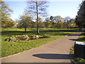
9
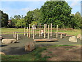
Parkour equipment, Lammas Park, Ealing
This set of eqipment was opened in September 2023 as a set of interconnecting vertical posts and horizontal bars, with some stone blocks scattered some way out. An account in My London News https://www.mylondon.news/news/west-london-news/ealing-council-lammas-park-parkour-14368495 of the original proposal showed blocks and walls for free running, what has been installed is more a climbing frame.
Image: © David Hawgood
Taken: 25 Sep 2023
0.08 miles
10
![Ealing features [12]](https://s2.geograph.org.uk/geophotos/06/36/79/6367922_967668f1_120x120.jpg)
Ealing features [12]
Five a side football pitches in Lammas Park.
The park is named after the original use of the land as lammas land where tenants of the manor could graze their cattle following harvest. Opened as a public park in 1883 and now a centre of sporting activities.
Ealing is one of the seven major towns in the London Borough of Ealing. A rural village until communications with London got better with the improvements to the road to Oxford (later Uxbridge Road) in the 18th century and culminating with the coming of the railway in 1838. Ealing expanded greatly with suburban development during the 19th century and became known as the "Queen of the Suburbs" due to its greenery and because it was halfway between city and country. Ealing became a municipal borough in 1901. Growth continued throughout the 20th century and Ealing became part of a modern London borough in 1965.
Image: © Michael Dibb
Taken: 14 Sep 2019
0.10 miles