IMAGES TAKEN NEAR TO
Broomfield Place, LONDON, W13 9LB
Introduction
This page details the photographs taken nearby to Broomfield Place, W13 9LB by members of the Geograph project.
The Geograph project started in 2005 with the aim of publishing, organising and preserving representative images for every square kilometre of Great Britain, Ireland and the Isle of Man.

There are currently over 7.5m images from over14,400 individuals and you can help contribute to the project by visiting https://www.geograph.org.uk
Image Map
Images are licensed for reuse under creativecommons.org/licenses/by-sa/2.0
Notes
- Clicking on the map will re-center to the selected point.
- The higher the marker number, the further away the image location is from the centre of the postcode.
Image Listing (122 Images Found)
Images are licensed for reuse under creativecommons.org/licenses/by-sa/2.0
Image
Details
Distance
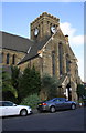
1
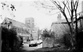
St John's Church and Deans Villas, Mattock Lane, Ealing
St John's Church was completed in 1875. It is now in a conservation area see "Ealing Green conservation area character appraisal". It is possible that the name Deans Villas is related to the church as they were owned by the church in the early and middle part of the 20th century and were rented to tenants.
Image: © Tom Jolliffe
Taken: Unknown
0.01 miles
3
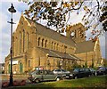
St John, Mattock Lane, London W13 - East end
Image: © John Salmon
Taken: 3 Nov 2004
0.02 miles
4
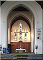
St John, Mattock Lane, London W13 - Chancel
Image: © John Salmon
Taken: 3 Nov 2004
0.02 miles
5
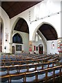
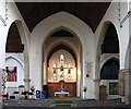
St John, Mattock Lane, London W13 - Arcade
Image: © John Salmon
Taken: 3 Nov 2004
0.02 miles
6

St John, Mattock Lane, London W13 - Window
Image: © John Salmon
Taken: 3 Nov 2004
0.02 miles
7
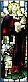
St John, Matlock Lane, London W13 - Window
Image: © John Salmon
Taken: 3 Nov 2004
0.02 miles
8
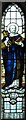
St John, Mattock Lane, London W13 - Window
Image: © John Salmon
Taken: 3 Nov 2004
0.02 miles
9
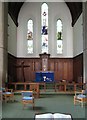
St John, Mattock Lane, London W13 - Chancel
Image: © John Salmon
Taken: 3 Nov 2004
0.02 miles
10
St John's Church from Mattock Lane
There is an OS benchmark Image at the base of the buttress on the near corner of the building, behind the conifer. There was a flagstaff on the tower which was an OS intersected station trig point, http://trigpointing.uk/trig/24242 , which was destroyed in May 1981
Image: © Roger Templeman
Taken: 16 Nov 2015
0.02 miles