IMAGES TAKEN NEAR TO
Chapel Road, LONDON, W13 9AE
Introduction
This page details the photographs taken nearby to Chapel Road, W13 9AE by members of the Geograph project.
The Geograph project started in 2005 with the aim of publishing, organising and preserving representative images for every square kilometre of Great Britain, Ireland and the Isle of Man.

There are currently over 7.5m images from over14,400 individuals and you can help contribute to the project by visiting https://www.geograph.org.uk
Image Map (Loading...)


Getting Data...Please wait
Leaflet Map data © OpenStreetMap
Images are licensed for reuse under creativecommons.org/licenses/by-sa/2.0
Notes
- Clicking on the map will re-center to the selected point.
- The higher the marker number, the further away the image location is from the centre of the postcode.
Image Listing (154 Images Found)
Images are licensed for reuse under creativecommons.org/licenses/by-sa/2.0
Image
Details
Distance
1
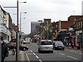
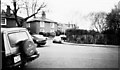
Uxbridge Road, West Ealing, London W13
Looking east along the Uxbridge Road towards Ealing Broadway (out of sight). The road joining on the right is Hartington Road. Uxbridge Road is the route of the proposed West London Tram, which is not popular in some parts: http://www.ealingstreets.org
Image: © Peter Jordan
Taken: 18 Mar 2006
0.01 miles
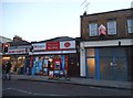
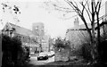
4

Deans Villas, Mattock lane, Ealing
Seen from St John's Church. Small semi-detached early Victorian cottages. Facing towards footpath to Northfields allotments.
Also see http://www.geograph.org.uk/photo/684470
Image: © Tom Jolliffe
Taken: Unknown
0.04 miles
6
![Ealing houses [8]](https://s0.geograph.org.uk/geophotos/06/36/70/6367012_b00d2042_120x120.jpg)
Ealing houses [8]
A fine pair of semi-detached houses at numbers 53 and 54 Mattock Lane.
Ealing is one of the seven major towns in the London Borough of Ealing. A rural village until communications with London got better with the improvements to the road to Oxford (later Uxbridge Road) in the 18th century and culminating with the coming of the railway in 1838. Ealing expanded greatly with suburban development during the 19th century and became known as the "Queen of the Suburbs" due to its greenery and because it was halfway between city and country. Ealing became a municipal borough in 1901. Growth continued throughout the 20th century and Ealing became part of a modern London borough in 1965.
Image: © Michael Dibb
Taken: 14 Sep 2019
0.04 miles
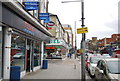
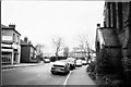
7
Mattock Lane, Ealing
Early Victorian Cottages, Mattock lane. The name "Mattock", may reflect the agricultural history of this area. Northfields allotments still exist within 50 metres of these cottages.
Also see http://www.geograph.org.uk/photo/684470
Image: © Tom Jolliffe
Taken: Unknown
0.05 miles
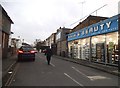
9
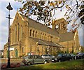
St John's Church, Mattock Lane, Ealing
The side porch of St John's church is on the immediate right. The parade of shops on Mattock Lane is opposite.
Image: © Tom Jolliffe
Taken: Unknown
0.05 miles
10
St John's Church and Deans Villas, Mattock Lane, Ealing
St John's Church was completed in 1875. It is now in a conservation area see "Ealing Green conservation area character appraisal". It is possible that the name Deans Villas is related to the church as they were owned by the church in the early and middle part of the 20th century and were rented to tenants.
Image: © Tom Jolliffe
Taken: Unknown
0.05 miles