IMAGES TAKEN NEAR TO
Cleveland Road, LONDON, W13 0EN
Introduction
This page details the photographs taken nearby to Cleveland Road, W13 0EN by members of the Geograph project.
The Geograph project started in 2005 with the aim of publishing, organising and preserving representative images for every square kilometre of Great Britain, Ireland and the Isle of Man.

There are currently over 7.5m images from over14,400 individuals and you can help contribute to the project by visiting https://www.geograph.org.uk
Image Map
Images are licensed for reuse under creativecommons.org/licenses/by-sa/2.0
Notes
- Clicking on the map will re-center to the selected point.
- The higher the marker number, the further away the image location is from the centre of the postcode.
Image Listing (52 Images Found)
Images are licensed for reuse under creativecommons.org/licenses/by-sa/2.0
Image
Details
Distance
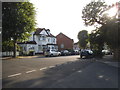
1
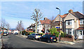
Cleveland Road, Ealing
Typical road for this area.
Image: © Des Blenkinsopp
Taken: 20 Jan 2020
0.03 miles
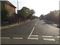
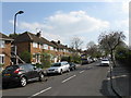
5
Highview Road at the junction of Claremont Road
Image: © David Howard
Taken: 4 Jul 2015
0.08 miles
6
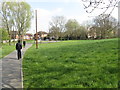
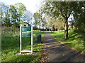
Open ground by Castle Bar Park station
Image: © Peter Whatley
Taken: 2 Apr 2012
0.10 miles
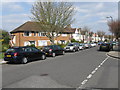
8
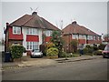
Semidetached Houses on Claremont Road
Housing close to Castle Bar Park Station.
Image: © James Emmans
Taken: 21 Nov 2019
0.12 miles
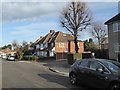
9
Footpath leading to Castle Bar Halt
The station is now known as Castle Bar Park but this sign records its original name.
Image: © Rod Allday
Taken: 13 Nov 2019
0.15 miles
10
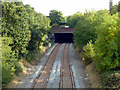
Railway south of Castle Bar Park station
The apparent tunnel was formerly a cutting. It was roofed over with a concrete slab and part of the GLC's Copley Close Estate was built over it, opened in 1979. The southern part of the Copley Close road runs directly over the railway.
Image: © Robin Webster
Taken: 13 Oct 2012
0.15 miles