IMAGES TAKEN NEAR TO
Leysfield Road, LONDON, W12 9JF
Introduction
This page details the photographs taken nearby to Leysfield Road, W12 9JF by members of the Geograph project.
The Geograph project started in 2005 with the aim of publishing, organising and preserving representative images for every square kilometre of Great Britain, Ireland and the Isle of Man.

There are currently over 7.5m images from over14,400 individuals and you can help contribute to the project by visiting https://www.geograph.org.uk
Image Map
Images are licensed for reuse under creativecommons.org/licenses/by-sa/2.0
Notes
- Clicking on the map will re-center to the selected point.
- The higher the marker number, the further away the image location is from the centre of the postcode.
Image Listing (69 Images Found)
Images are licensed for reuse under creativecommons.org/licenses/by-sa/2.0
Image
Details
Distance
1
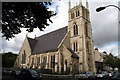
Shepherd's Bush: St. Andrew Bobola's Polish R C Church
It is very difficult to get far enough away from the building to get a decent photograph of this very attractive church
Image: © Dr Neil Clifton
Taken: 2 Oct 2012
0.04 miles
2

St Andrews Polish RC Church
This church is indicative of the cosmopolitan area in these few square kilometres of London around Chiswick, Turnham Green, Ravenscourt Park etc. It is situated just south west of the centre of the grid square. This picture was taken from the north east of the building.
Image: © Pam Brophy
Taken: 10 May 2005
0.04 miles
3

A suburban Garden Flower
Clematis is an extremely popular creeper grown in British gardens. This was from a garden along the A402 south west of where the church is situated.
Image: © Pam Brophy
Taken: 10 May 2005
0.04 miles
4

St Andrew Bobola RC Polish Church Hammersmith
In the 1960's this church became London's first Polish church, even though the Polish community have been in the Hammersmith much longer than that. Before the 1960's the Poles were probably happy to join the english speaking RC churches.
Image: © James Emmans
Taken: 2 Jun 2022
0.06 miles
5

Melville Court, Hammersmith
A block of flats on the Goldhawk Road
Image: © David Hawgood
Taken: 3 May 2008
0.06 miles
6
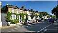
Greenside Road
Old terrace houses with typical sash windows.
Image: © James Emmans
Taken: 2 Jun 2022
0.07 miles
7

Filling station, Goldhawk Road
A filling station on this busy road in Hammersmith.
Image: © David Hawgood
Taken: 3 May 2008
0.07 miles
8

Hammersmith Academy
Modern school building, as seen from Melina Road.
Looks like a football stadium, being oval in design.
Image: © David Anstiss
Taken: 14 Apr 2013
0.08 miles
9
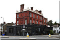
Goldhawk Road: The 'Seven Stars'
Closed as a pub (shows effect of painting it black) and now reduced to being a mere Asian takeaway (like the country needs more Asian takeaways...)
Image: © Dr Neil Clifton
Taken: 2 Oct 2012
0.09 miles