IMAGES TAKEN NEAR TO
Lime Grove, LONDON, W12 8ED
Introduction
This page details the photographs taken nearby to Lime Grove, W12 8ED by members of the Geograph project.
The Geograph project started in 2005 with the aim of publishing, organising and preserving representative images for every square kilometre of Great Britain, Ireland and the Isle of Man.

There are currently over 7.5m images from over14,400 individuals and you can help contribute to the project by visiting https://www.geograph.org.uk
Image Map
Images are licensed for reuse under creativecommons.org/licenses/by-sa/2.0
Notes
- Clicking on the map will re-center to the selected point.
- The higher the marker number, the further away the image location is from the centre of the postcode.
Image Listing (259 Images Found)
Images are licensed for reuse under creativecommons.org/licenses/by-sa/2.0
Image
Details
Distance
1
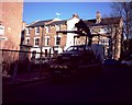
Council Tow Truck
A sign of the times, a council tow truck placing an illegally parked car on the back waiting to take it to the car pound.
Image: © Phillip Perry
Taken: 8 Feb 2008
0.01 miles
3
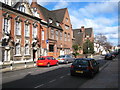
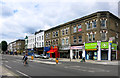
Lime Grove Shepherd's Bush
The building on the left is the Hammersmith Public Baths & Washhouse building, scene of boxing matches and was familiar to viewers of 1960s Saturday afternoon TV wrestling programmes as Lime Grove Baths. It was also the location for the baths scene in the 1979 film 'Quadrophenia'. The building next to it is now part of the London College of Fashion but was constructed in 1904 as the Hammersmith College of Art & Building.
Image: © Rod Allday
Taken: 6 Mar 2010
0.03 miles
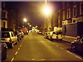
4

Titmuss Street W12
From the junction with Goldhawk Road W12
Image: © Robin Sones
Taken: 19 Mar 2010
0.04 miles
5
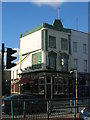
Shepherd and Flock, Goldhawk Road W12
At the junction with Titmuss Street W12
Image: © Robin Sones
Taken: 19 May 2009
0.04 miles
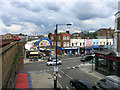
6

Lime Grove at the junction of Goldhawk Road
Image: © David Howard
Taken: 12 Apr 2014
0.05 miles
7
Goldhawk Road
This is from Wikipedia, with thanks:-
"Goldhawk Road's name derives from John Goldhawk, who in the late 14th century held extensive estates in Fulham.
Goldhawk Road was of little note until the mid-seventeenth century, when a cottage on the street became the home of Miles Sindercombe, a disgruntled Roundhead who in 1657 made several attempts to assassinate Oliver Cromwell. Sindercombe planned to ambush the Lord Protector using a specially built machine with muskets fixed to a frame. His plan failed, Sindercombe was sentenced to death, and his cottage was eventually demolished in the 1760s."
https://en.wikipedia.org/wiki/Goldhawk_Road
Image: © Des Blenkinsopp
Taken: 30 Jul 2015
0.05 miles
8
Shepherds Bush Market
The Goldhawk Road entrance.
Image: © Des Blenkinsopp
Taken: 30 Jul 2015
0.06 miles
9

The Prince, Goldhawk Road W12
At the junction with Richford Street W12
Image: © Robin Sones
Taken: 19 May 2009
0.06 miles
