IMAGES TAKEN NEAR TO
Tunis Road, LONDON, W12 7EP
Introduction
This page details the photographs taken nearby to Tunis Road, W12 7EP by members of the Geograph project.
The Geograph project started in 2005 with the aim of publishing, organising and preserving representative images for every square kilometre of Great Britain, Ireland and the Isle of Man.

There are currently over 7.5m images from over14,400 individuals and you can help contribute to the project by visiting https://www.geograph.org.uk
Image Map
Images are licensed for reuse under creativecommons.org/licenses/by-sa/2.0
Notes
- Clicking on the map will re-center to the selected point.
- The higher the marker number, the further away the image location is from the centre of the postcode.
Image Listing (283 Images Found)
Images are licensed for reuse under creativecommons.org/licenses/by-sa/2.0
Image
Details
Distance
1
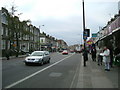
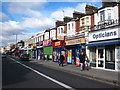
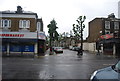
Uxbridge Road, W12
Uxbridge Road corner of Tunis Road looking towards East Acton.
Image: © Phillip Perry
Taken: 7 Feb 2008
0.02 miles
2
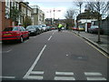
Tunis Road, W12 (2)
Tunis Road junction of Abdale road and out of shot to the right Stanlake Villas, the other side of this road on the right is in the next square to the right of this one (TQ 2281).
Image: © Phillip Perry
Taken: 7 Feb 2008
0.03 miles
4
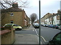
Stanlake Villas
Stanlake Villas looking east, on the right (the grey wall) is the back gate of Shepherd's Bush police station, the man on the bike wearing a high visibility jacket is a PCSO.
Image: © Phillip Perry
Taken: 7 Feb 2008
0.03 miles
6
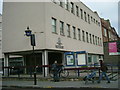
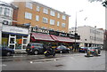
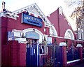
Shepherd's Bush Police Station
Shepherd's Bush Police Station, corner of Uxbridge Road and Tunis Road.
Image: © Phillip Perry
Taken: 7 Feb 2008
0.04 miles
7
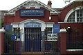
Polling station - No.50
For one day only, this will be used as a local polling station for both the local council and general election.
It's real use is a church, before that it was the former W12 Royal Mail sorting office. The 50 refers to 50/59 polling stations in the London Borough of Hammersmith & Fulham. The Westminster constitunency is for the newly created seat of Hammersmith,
the council ward is Shepherd's Bush Green.
Image: © Phillip Perry
Taken: 5 May 2010
0.04 miles
8
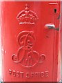
Edward VII postbox, Loftus Road, W12 - royal cipher
See Image
Image: © Mike Quinn
Taken: 25 Jun 2008
0.04 miles
10
Church of God - Loftus Road
The former W12 Royal Mail sorting office is now a church and a polling station for elections.
Image: © Phillip Perry
Taken: 8 Feb 2008
0.05 miles