IMAGES TAKEN NEAR TO
Steventon Road, LONDON, W12 0SL
Introduction
This page details the photographs taken nearby to Steventon Road, W12 0SL by members of the Geograph project.
The Geograph project started in 2005 with the aim of publishing, organising and preserving representative images for every square kilometre of Great Britain, Ireland and the Isle of Man.

There are currently over 7.5m images from over14,400 individuals and you can help contribute to the project by visiting https://www.geograph.org.uk
Image Map
Images are licensed for reuse under creativecommons.org/licenses/by-sa/2.0
Notes
- Clicking on the map will re-center to the selected point.
- The higher the marker number, the further away the image location is from the centre of the postcode.
Image Listing (65 Images Found)
Images are licensed for reuse under creativecommons.org/licenses/by-sa/2.0
Image
Details
Distance
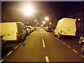
1
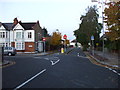
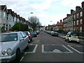
Steventon Road II, W12
Junction of Steventon Road, Sedgeford Road & Wallflower Street. Also see: Image
Image: © Phillip Perry
Taken: 9 Nov 2008
0.04 miles
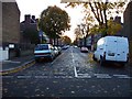
3
John on the Sidewalk
An American title for a change.
It would be Toilet on the Pavement in Brit, but that lacks style, somehow.
No idea what this is about.
Casual dumping?
All part of the scenery along Wallflower Gardens W12.
Image: © Des Blenkinsopp
Taken: 13 Apr 2017
0.05 miles
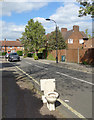
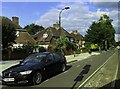
4
Sundew Ave/Stephenton Rd, W12
A triangular junction where Sundew Ave. and Stephenton Rd. meet.
Image: © Phillip Perry
Taken: 9 Jun 2008
0.05 miles
5
Sawley Road, W12
Sawley Road looking towards Wormholt Road.
Image: © Phillip Perry
Taken: 9 Jun 2008
0.06 miles
7
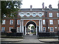
Entrance to the Peabody Estate
Seen across Steventon Road, nobody could accuse the Peabody Estate of stinting on its architecture. The date of 1928 is above an entrance that many stately homes would be proud of.
Image: © Marathon
Taken: 23 Jul 2014
0.09 miles
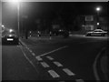
8
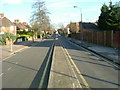
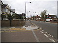
Steventon Road, W12
A rather unusual way of dividing a road, it's not a dual carriageway as we would know it and you can only drive down the right hand lane as you look at it. It's only one way going away from the picture, yet on the left side is access to a few houses. This has to be about 100 yards/metres long. Also see:Image
Image: © Phillip Perry
Taken: 1 Feb 2008
0.09 miles
9
Old Oak Road at the junction of Ashfield Road
Image: © David Howard
Taken: 13 Jun 2015
0.10 miles
10
Aycliffe Road, W12
Aycliffe Road, W12
Image: © Phillip Perry
Taken: 29 Feb 2008
0.11 miles