IMAGES TAKEN NEAR TO
Heathstan Road, LONDON, W12 0RD
Introduction
This page details the photographs taken nearby to Heathstan Road, W12 0RD by members of the Geograph project.
The Geograph project started in 2005 with the aim of publishing, organising and preserving representative images for every square kilometre of Great Britain, Ireland and the Isle of Man.

There are currently over 7.5m images from over14,400 individuals and you can help contribute to the project by visiting https://www.geograph.org.uk
Image Map
Images are licensed for reuse under creativecommons.org/licenses/by-sa/2.0
Notes
- Clicking on the map will re-center to the selected point.
- The higher the marker number, the further away the image location is from the centre of the postcode.
Image Listing (123 Images Found)
Images are licensed for reuse under creativecommons.org/licenses/by-sa/2.0
Image
Details
Distance
1
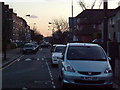
Bentworth Road
Bentworth Road looking across Westway and down Bloemfontein Road.
Image: © Phillip Perry
Taken: 30 Jan 2008
0.04 miles
2
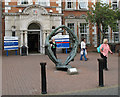
Circle of Life
Sculpture outside the main entrance to Hammersmith Hospital.
Image: © Martin Addison
Taken: 14 Sep 2006
0.05 miles
3
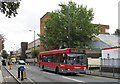
Du Cane Road
A number 72 bus nears the end of its journey in East Acton as it passes Hammersmith Hospital. The footbridge on the right carries pedestrians across the Central Line to Bentworth Road. In the background is O'Driscoll House on the local estate.
Image: © Martin Addison
Taken: 14 Sep 2006
0.05 miles
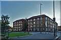
4
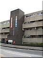
O'Driscoll House
Detail of the centre of this block of flats showing the walkways and, I believe, the refuse shute. The artistic hoardings add a splash of colour to an otherwise drab scene
Image: © Martin Addison
Taken: 14 Sep 2006
0.05 miles
5
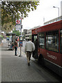
Boarding the bus
Passengers board a number 72 bus outside Hammersmith Hospital. This bus routes from East Acton to Roehampton. The bus stop is of the current aluminium post type. London Transport used to produce their own design in pink concrete.
Image: © Martin Addison
Taken: 14 Sep 2006
0.05 miles
6
Westway A40 (T)
Looking towards Wood Lane and White City, on the corner of Bentworth Road, W12.
On the right on the other side of the road is part of the White City estate, further down on the right is the BBC White City complex.
Image: © Phillip Perry
Taken: 30 Jan 2008
0.05 miles
8
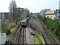
Engineering train on Central Line
The Central Line was closed for the weekend west of Marble Arch. This train is taking spent ballast away from track renewal operations at White City. Battery-electric locomotives are at front and rear, the nearest one, L31, being at the rear. The train is the same one as seen in the distance in Image about twenty minutes earlier.
Image: © Robin Webster
Taken: 27 Mar 2011
0.06 miles
9
Creighton Close, Bloemfontein Road, W12
Part of the White City Estate, Creighton Close.
Image: © Phillip Perry
Taken: 9 Jun 2008
0.06 miles
10
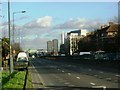
A40 Westway, view to Imperial College White City tower
View from bus stop (for 95 bus) past Bloemfontein Road with the Skyscraper building of Imperial City Campus beyond. See Image for photo of that tower under construction. For a night photo at this bus stop see Image Houses on the left are in a narrow strip between Westway and the Central Line, above ground in this area. On the right are modern flats accessed from Jopling Close.
Image: © David Hawgood
Taken: 11 Jun 2022
0.06 miles