IMAGES TAKEN NEAR TO
Horbury Mews, LONDON, W11 3NL
Introduction
This page details the photographs taken nearby to Horbury Mews, W11 3NL by members of the Geograph project.
The Geograph project started in 2005 with the aim of publishing, organising and preserving representative images for every square kilometre of Great Britain, Ireland and the Isle of Man.

There are currently over 7.5m images from over14,400 individuals and you can help contribute to the project by visiting https://www.geograph.org.uk
Image Map
Images are licensed for reuse under creativecommons.org/licenses/by-sa/2.0
Notes
- Clicking on the map will re-center to the selected point.
- The higher the marker number, the further away the image location is from the centre of the postcode.
Image Listing (413 Images Found)
Images are licensed for reuse under creativecommons.org/licenses/by-sa/2.0
Image
Details
Distance
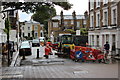
3
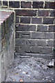
Benchmark on #24 Ladbroke Road
Ordnance Survey cut mark benchmark described on the Bench Mark Database at http://www.bench-marks.org.uk/bm41802
Image: © Roger Templeman
Taken: 10 Mar 2012
0.05 miles
4
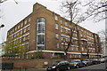
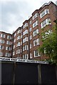
Bowden Court hostel, #24 Ladbroke Road
There is an OS benchmark Image on the Ladbroke Terrace face of the hostel
Image: © Roger Templeman
Taken: 10 Mar 2012
0.05 miles
7
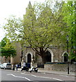
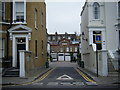
South side of Kensington Temple, London
Viewed across Ladbroke Road. The temple is on the corner of Kensington Park Road.
Officially opened in September 1849 as Horbury Chapel, Notting Hill, part of the Congregational Church. In 1931, the church was sold to a new and growing movement known as Elim Foursquare Gospel Alliance. It is now (2012) known as Kensington Temple, part of Elim Pentecostal Church.
Image: © Jaggery
Taken: 13 May 2012
0.08 miles

9
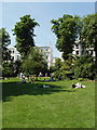
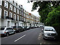
Ladbroke Square Gardens
This area was laid out as a racecourse in 1837, then in 1849 became a communal private garden for residents of adjoining streets of the Ladbroke estate. See also Image
Image: © David Hawgood
Taken: 8 Jun 2008
0.09 miles