IMAGES TAKEN NEAR TO
Victoria Mews, LONDON, W11 3AE
Introduction
This page details the photographs taken nearby to Victoria Mews, W11 3AE by members of the Geograph project.
The Geograph project started in 2005 with the aim of publishing, organising and preserving representative images for every square kilometre of Great Britain, Ireland and the Isle of Man.

There are currently over 7.5m images from over14,400 individuals and you can help contribute to the project by visiting https://www.geograph.org.uk
Image Map (Loading...)


Getting Data...Please wait
Leaflet Map data © OpenStreetMap
Images are licensed for reuse under creativecommons.org/licenses/by-sa/2.0
Notes
- Clicking on the map will re-center to the selected point.
- The higher the marker number, the further away the image location is from the centre of the postcode.
Image Listing (399 Images Found)
Images are licensed for reuse under creativecommons.org/licenses/by-sa/2.0
Image
Details
Distance
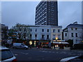
1
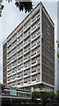
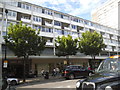
Campden Hill Tower, Notting Hill Gate
People associate this area, if they think about it at all, with stucco terraces, bijou boutiques and Hugh Grant, but the area around the tube station is liberally dotted with 1960s concrete, redeveloped by Cotton Ballard & Blow for the London County Council in 1962. Exposed and aggregrate-clad concrete block of flats (each with its own fire escape to the floor below) on a podium with shops at street level.
Image: © Stephen Richards
Taken: 17 Jul 2011
0.03 miles
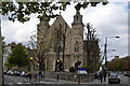
2
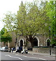
South side of Kensington Temple, London
Viewed across Ladbroke Road. The temple is on the corner of Kensington Park Road.
Officially opened in September 1849 as Horbury Chapel, Notting Hill, part of the Congregational Church. In 1931, the church was sold to a new and growing movement known as Elim Foursquare Gospel Alliance. It is now (2012) known as Kensington Temple, part of Elim Pentecostal Church.
Image: © Jaggery
Taken: 13 May 2012
0.03 miles
3
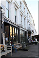
Shops on Ladbroke Road
A short parade of shops at the eastern end of the road adjacent to the junction with Kensington Park Road.
Image: © Martin Addison
Taken: 27 Jan 2012
0.04 miles
4
Coloured buildings on Portobello Road #4
You can't see them too clearly in the failing light, but here's another collection of coloured buildings, this time at the junction of Kensington Park and Ladbroke Roads. View taken looking west-southwest.
Image: © Robert Lamb
Taken: 20 Nov 2010
0.04 miles
5
Kensington Temple
Grade II listed. http://www.britishlistedbuildings.co.uk/101224188-kensington-temple-pembridge-ward
Image: © N Chadwick
Taken: 1 May 2017
0.04 miles
6
Kensington Temple and Cab Drivers shelter
Both are Grade II listed. http://www.britishlistedbuildings.co.uk/101224188-kensington-temple-pembridge-ward & http://www.britishlistedbuildings.co.uk/101227410-cabmens-shelter-to-centre-ground-outside-numbers-8-and-10-pembridge-ward
Image: © N Chadwick
Taken: 1 May 2017
0.04 miles
7
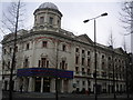
Coronet Cinema, Notting Hill Gate W2
At the junction of Hillgate Street W8
Image: © Robin Sones
Taken: 18 Jan 2010
0.04 miles
8
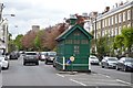
Cab Drivers Shelter
Grade II listed. http://www.britishlistedbuildings.co.uk/101227410-cabmens-shelter-to-centre-ground-outside-numbers-8-and-10-pembridge-ward
Image: © N Chadwick
Taken: 1 May 2017
0.04 miles