IMAGES TAKEN NEAR TO
Ladbroke Grove, LONDON, W10 6HA
Introduction
This page details the photographs taken nearby to Ladbroke Grove, W10 6HA by members of the Geograph project.
The Geograph project started in 2005 with the aim of publishing, organising and preserving representative images for every square kilometre of Great Britain, Ireland and the Isle of Man.

There are currently over 7.5m images from over14,400 individuals and you can help contribute to the project by visiting https://www.geograph.org.uk
Image Map
Images are licensed for reuse under creativecommons.org/licenses/by-sa/2.0
Notes
- Clicking on the map will re-center to the selected point.
- The higher the marker number, the further away the image location is from the centre of the postcode.
Image Listing (254 Images Found)
Images are licensed for reuse under creativecommons.org/licenses/by-sa/2.0
Image
Details
Distance

2
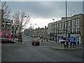
Ladbroke Grove, W10
At the junction of Barlby Road, looking south.
Image: © Danny P Robinson
Taken: 4 Feb 2007
0.03 miles
4
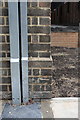
Benchmark on Bruce Close face of Burleigh House, Ladbrook Grove
Ordnance Survey cut mark benchmark described on the Bench Mark Database at http://www.bench-marks.org.uk/bm38029
Image: © Roger Templeman
Taken: 20 May 2011
0.05 miles
5

Alleyway to Wornington Road
Passing under a network of concrete beams between two blocks of housing on
Ladbroke Grove.
Compare with Image
Image: © David Anstiss
Taken: 6 Dec 2013
0.05 miles
6

Alleyway to Ladbroke Grove
As seen from Wornington Road.
The alley leads under a network of concrete beams between two blocks of housing on Ladbroke Grove.
Compare with Image
Image: © David Anstiss
Taken: 6 Dec 2013
0.05 miles
7
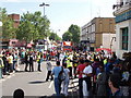
Notting Hill Carnival - Ladbroke Grove
Large crowds, but plenty of police and stewards to guide and control them. Each float has its own stewards who keep the way clear for the dancers and vehicles, and the carnival also has plenty of stewards.
Image: © David Hawgood
Taken: 30 Aug 2010
0.05 miles
8

The Cowshed
Looks like it's not just country pubs that are closing down. The rail bridge to the right carries Ladbroke Grove over the main line west out of Paddington.
Image: © Stuart Logan
Taken: 22 Jan 2012
0.05 miles
9

Hewer Street, W10
3 different types of flats.
Image: © Phillip Perry
Taken: 19 Jul 2008
0.06 miles
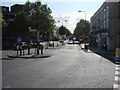
10
Portobello Road / Wornington Road, W10
The famous market is a few hundred metres ahead, out of sight. There is a pedestrian cut-through to the right of me that leads onto Ladbroke Grove. To the left of me is Wornington Road, leading towards Westbourne Park.
Image: © Danny P Robinson
Taken: 4 Feb 2007
0.06 miles