IMAGES TAKEN NEAR TO
Kensal Road, LONDON, W10 5JU
Introduction
This page details the photographs taken nearby to Kensal Road, W10 5JU by members of the Geograph project.
The Geograph project started in 2005 with the aim of publishing, organising and preserving representative images for every square kilometre of Great Britain, Ireland and the Isle of Man.

There are currently over 7.5m images from over14,400 individuals and you can help contribute to the project by visiting https://www.geograph.org.uk
Image Map
Images are licensed for reuse under creativecommons.org/licenses/by-sa/2.0
Notes
- Clicking on the map will re-center to the selected point.
- The higher the marker number, the further away the image location is from the centre of the postcode.
Image Listing (313 Images Found)
Images are licensed for reuse under creativecommons.org/licenses/by-sa/2.0
Image
Details
Distance
1
Ellesmere - narrowboat on Paddington Arm, Grand Union Canal
Ellesmere, from Calcutt, is the red boat in shade under the tree.
Image: © David Hawgood
Taken: 27 Apr 2015
0.01 miles
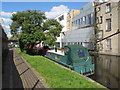
2

Footbridge 4ab Paddington Arm - access from Portobello Dock complex
There is public access to this area with outdoor seating for the Dock Kitchen restaurant, and the Tom Dixon shop, but no public access through to Harrow Road beyond the bridge.
Image: © David Hawgood
Taken: 15 Dec 2011
0.02 miles
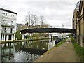
3

Grand Union Canal, Paddington Arm
The Paddington Arm of the then Grand Junction Canal was opened in 1801 from Bull's Bridge near Southall to Paddington Basin. The canals were initially a success, particularly for transporting coal, building materials and other bulky loads, but the rise of the railways not long after the canals were built substantially reduced their importance. Now they are primarily a leisure facility. The Paddington Arm was one of the last to see the old-fashioned style of regular commercial traffic of paired narrow boats carrying the traditional materials such as coal, oils, and tar. The Paddington Arm now sees regular commercial traffic, usually in the form of aggregates. What was then the Central Electricity Generating Board laid cables under some of the towpaths in the 1970s, as seen here, and made them suitable for pedestrians again.
The towpath is followed by the Grand Union Canal Walk. This section is between Great Western Road and Ladbroke Grove. The houses on the opposite side are on Harrow Road. Ladbroke Grove is just ahead beyond the footbridge.
Image: © Marathon
Taken: 4 Dec 2013
0.02 miles
4

Footbridge over canal
This is a fairly modern bridge where none existed before.
Image: © Robin Webster
Taken: 12 Feb 2011
0.02 miles


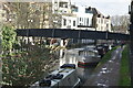
7
Kensal Town, footbridge
Bridge No 4ab, connecting Harrow Road and Kensal Road over Grand Union Canal (Paddington Branch).
Image: © Mike Faherty
Taken: 9 Apr 2016
0.02 miles
9

Kensal Road, Kensal Town
Kensal Road at Kensal Town in north west London.
Image: © Malc McDonald
Taken: 29 Aug 2015
0.02 miles
10

Footbridge 4ab Paddington Arm - within Portobello Dock complex
There is public access to the Portobello Dock end of the bridge on the left, but no public access to the Harrow Road at the right. The towpath surface under the bridge is rolled and sealed gravel. Closer to the camera it switches to paving stones.
Image: © David Hawgood
Taken: 15 Dec 2011
0.02 miles