IMAGES TAKEN NEAR TO
Manchester Drive, LONDON, W10 5BG
Introduction
This page details the photographs taken nearby to Manchester Drive, W10 5BG by members of the Geograph project.
The Geograph project started in 2005 with the aim of publishing, organising and preserving representative images for every square kilometre of Great Britain, Ireland and the Isle of Man.

There are currently over 7.5m images from over14,400 individuals and you can help contribute to the project by visiting https://www.geograph.org.uk
Image Map
Images are licensed for reuse under creativecommons.org/licenses/by-sa/2.0
Notes
- Clicking on the map will re-center to the selected point.
- The higher the marker number, the further away the image location is from the centre of the postcode.
Image Listing (381 Images Found)
Images are licensed for reuse under creativecommons.org/licenses/by-sa/2.0
Image
Details
Distance
1
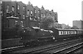
Ex GWR large prairie 2-6-2T locomotive 6142 near Westbourne Park, 1960
Bringing a rake of empty coaches into Paddington for an express working. This class of locomotive formed the principal motive power for commuter services out of Paddington as well as doing empty stock work.
The houses in the background have been replaced by modern maisonettes.
Image: © Alan Murray-Rust
Taken: Unknown
0.05 miles

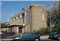
3
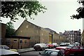
Former Middle Row Bus Garage
Situated in Conlan Street, North Kensington, this former bus garage was opened in May 1910 and operated Routemaster buses from the early 1960s, although X-type and AEC RT double-deckers were based there in the earlier decades. It closed in August 1981, with the vehicles being transferred to the new Westbourne Park garage, TQ2481 refers. The building is now used as industrial premises and its postcode is W10 5AR.
Image: © David Hillas
Taken: 2 Jun 1992
0.09 miles
4
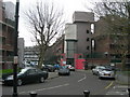
Portobello Road / Wornington Road, W10
The famous market is a few hundred metres ahead, out of sight. There is a pedestrian cut-through to the right of me that leads onto Ladbroke Grove. To the left of me is Wornington Road, leading towards Westbourne Park.
Image: © Danny P Robinson
Taken: 4 Feb 2007
0.10 miles
5
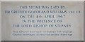
St Thomas, Kensal Road, London W10 - Foundation stone
Image: © John Salmon
Taken: 27 Apr 2010
0.10 miles
9

Alleyway to Wornington Road
Passing under a network of concrete beams between two blocks of housing on
Ladbroke Grove.
Compare with Image
Image: © David Anstiss
Taken: 6 Dec 2013
0.11 miles
10

Alleyway to Ladbroke Grove
As seen from Wornington Road.
The alley leads under a network of concrete beams between two blocks of housing on Ladbroke Grove.
Compare with Image
Image: © David Anstiss
Taken: 6 Dec 2013
0.11 miles