IMAGES TAKEN NEAR TO
Briar Walk, LONDON, W10 4QY
Introduction
This page details the photographs taken nearby to Briar Walk, W10 4QY by members of the Geograph project.
The Geograph project started in 2005 with the aim of publishing, organising and preserving representative images for every square kilometre of Great Britain, Ireland and the Isle of Man.

There are currently over 7.5m images from over14,400 individuals and you can help contribute to the project by visiting https://www.geograph.org.uk
Image Map
Images are licensed for reuse under creativecommons.org/licenses/by-sa/2.0
Notes
- Clicking on the map will re-center to the selected point.
- The higher the marker number, the further away the image location is from the centre of the postcode.
Image Listing (297 Images Found)
Images are licensed for reuse under creativecommons.org/licenses/by-sa/2.0
Image
Details
Distance
1
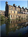
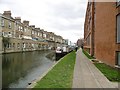
Terrace by the canal, Kensal Town
The west end of the terrace shown in Image
Image: © Derek Harper
Taken: 19 Mar 2012
0.02 miles
2
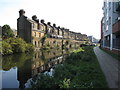
Harrow Road house-backs along the Grand Union Canal
Image: © Gareth James
Taken: 2 Sep 2017
0.02 miles
3
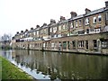
Shops and houses along the Harrow Road
Shops on the ground floor, with houses and back yards on the two floors above. Not sure how anyone gets to the canoe. Seen from the towpath of the Grand Union Canal's Paddington Branch.
Image: © Christine Johnstone
Taken: 28 Feb 2012
0.02 miles
4
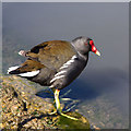
Moorhen by the canal
A moorhen Gallinula chloropus https://www.rspb.org.uk/wildlife/birdguide/name/m/moorhen/ on the Paddington Branch of the Grand Union Canal.
Image: © David P Howard
Taken: 13 Apr 2014
0.03 miles
5
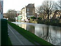
Kensal Town, moorings
Moorings on Grand Union Canal (Paddington Branch). Note houses on Harrow Road overlooking the canal.
Image: © Mike Faherty
Taken: 9 Apr 2016
0.03 miles
6
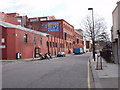
Warehouse converted to offices, Kensal Road
Image: © David Hawgood
Taken: 26 Feb 2007
0.03 miles
7
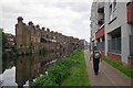
Harrow Road Homes
The Victorian houses on the far bank of the canal are in Harrow Road
Image: © Glyn Baker
Taken: 16 May 2014
0.03 miles
8
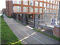
Paddington Arm - Alderson Street access
There is a ramp from the towpath down to Alderson Street, with steps as an alternative. The towpath here is surfaced with paving slabs. The building by the towpath is Nido Notting Hill student housing http://www.nidostudentliving.com/london/notting-hill/home.php with 277 beds mainly in single studios.
Image: © David Hawgood
Taken: 15 Dec 2011
0.03 miles
9
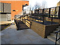
Paddington Arm - ramp to towpath from Alderson Street
This ramp has been installed this year as part of the development in Alderson Street of Nido student housing. The slope is 3° to 4° (between 1 in 20 and 1 in 15) so it is within the recommended maximum for wheelchair access.
Image: © David Hawgood
Taken: 15 Dec 2011
0.03 miles
10
Grand Union Canal - Harrow Road
In the middle of the picture the houses shown having a main road for a front garden, the back garden is a canal on the Grand Union Canal - Harrow Road opposite Queen's Park library.
Image: © Phillip Perry
Taken: 6 Feb 2007
0.03 miles