IMAGES TAKEN NEAR TO
Sycamore Walk, LONDON, W10 4DZ
Introduction
This page details the photographs taken nearby to Sycamore Walk, W10 4DZ by members of the Geograph project.
The Geograph project started in 2005 with the aim of publishing, organising and preserving representative images for every square kilometre of Great Britain, Ireland and the Isle of Man.

There are currently over 7.5m images from over14,400 individuals and you can help contribute to the project by visiting https://www.geograph.org.uk
Image Map
Images are licensed for reuse under creativecommons.org/licenses/by-sa/2.0
Notes
- Clicking on the map will re-center to the selected point.
- The higher the marker number, the further away the image location is from the centre of the postcode.
Image Listing (339 Images Found)
Images are licensed for reuse under creativecommons.org/licenses/by-sa/2.0
Image
Details
Distance
1
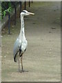
Waiting for a No. 18 bus
This heron was just standing there beside the Harrow Road. Surprising until you realise that with a couple of flaps it could be beside the Grand Union Canal. In Image this bird's position is just on the road side of the railings.
Image: © Roger W Haworth
Taken: 9 Jun 2010
0.02 miles
2
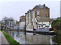
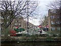
The Flora, Harrow Road
Seen from the towpath of the Grand Union Canal's Paddington Branch.
Image: © Christine Johnstone
Taken: 28 Feb 2012
0.02 miles
3
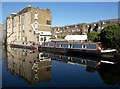
Narrowboat by the Flora
The pair of narrowboats moored by the pub are obviously permanent fixtures, appearing on satellite images as well as all photos of the pub; see also Image and Image
Image: © Derek Harper
Taken: 19 Mar 2012
0.03 miles
4
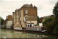
The Flora
Pub on Harrow Road, seen across the Grand Union Canal, Paddington Branch
Image: © Richard Croft
Taken: 6 Aug 2012
0.03 miles
5
Fifth Avenue, Kensal Rise
This is part of the Queen's Park estate, developed in the 1870s/80s by the Artizans', Labourers' and General Dwellings Company, with tree-lined roads and an area set aside for recreation. Gardening was encouraged and there was to be provision for an institute, cooperative stores, coal depot, dairy farm, baths, and reading rooms, but no public house. Avenues numbered from 1 to 6 were laid out leading north from Harrow Road and south to the canal, and connected by long cross streets. (Information from British History Online.)
Image: © Natasha Ceridwen de Chroustchoff
Taken: 14 Mar 2010
0.03 miles
6
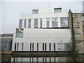
Metallic building next to the Flora pub, Harrow Road
Offices or housing? Difficult to tell. The 'first floor' wall hides a small courtyard. Seen from the towpath of the Grand Union Canal's Paddington Branch.
Image: © Christine Johnstone
Taken: 28 Feb 2012
0.03 miles
7
Grand Union Canal, West Kilburn
Similar to Image; see also Image The Flora has a couple of narrowboats moored outside. The white office building on the left is shown in Image
Image: © Derek Harper
Taken: 19 Mar 2012
0.03 miles
8
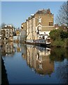
The Flora, Harrow Road W10
Not immediately recognizable as a pub from the canal side. It looks a good deal smarter from the road.
Image: © Robin Webster
Taken: 12 Feb 2011
0.03 miles
9
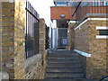
Paddington Arm - Adela Street access
These steps give access from Kensal Road via the short Adela Street to the canal towpath.
Image: © David Hawgood
Taken: 15 Dec 2011
0.03 miles
10
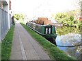
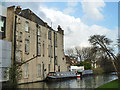
Lady Jane - narrowboat on Paddington Arm, Grand Union Canal
Image: © David Hawgood
Taken: 27 Apr 2015
0.03 miles