IMAGES TAKEN NEAR TO
Fifth Avenue, LONDON, W10 4DP
Introduction
This page details the photographs taken nearby to Fifth Avenue, W10 4DP by members of the Geograph project.
The Geograph project started in 2005 with the aim of publishing, organising and preserving representative images for every square kilometre of Great Britain, Ireland and the Isle of Man.

There are currently over 7.5m images from over14,400 individuals and you can help contribute to the project by visiting https://www.geograph.org.uk
Image Map (Loading...)


Getting Data...Please wait
Leaflet Map data © OpenStreetMap
Images are licensed for reuse under creativecommons.org/licenses/by-sa/2.0
Notes
- Clicking on the map will re-center to the selected point.
- The higher the marker number, the further away the image location is from the centre of the postcode.
Image Listing (171 Images Found)
Images are licensed for reuse under creativecommons.org/licenses/by-sa/2.0
Image
Details
Distance
1
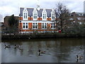
Four geese and a library
Queen's Park Library is at 666 Harrow Road between Fourth and Fifth Avenues and backs on to the canal.
Image: © Natasha Ceridwen de Chroustchoff
Taken: 14 Mar 2010
0.12 miles
2
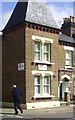
Droop Street & Sixth Avenue
Close up of the street corner featured in Image
Image: © Des Blenkinsopp
Taken: 7 Apr 2014
0.13 miles
3
Droop Street, W10
This is Droop Street.
As featured on "Funny British Street Names" http://www.thecareerbreaksite.com/funny-british-street-names.
and no doubt other sites.
At least it's in London, not Swindon or Salisbury.
Droop Street, Wilts, would be too bad....
Image: © Des Blenkinsopp
Taken: 7 Apr 2014
0.13 miles
4
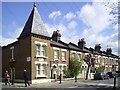
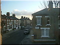
Fifth Avenue, Kensal Rise
This is part of the Queen's Park estate, developed in the 1870s/80s by the Artizans', Labourers' and General Dwellings Company, with tree-lined roads and an area set aside for recreation. Gardening was encouraged and there was to be provision for an institute, cooperative stores, coal depot, dairy farm, baths, and reading rooms, but no public house. Avenues numbered from 1 to 6 were laid out leading north from Harrow Road and south to the canal, and connected by long cross streets. (Information from British History Online.)
Image: © Natasha Ceridwen de Chroustchoff
Taken: 14 Mar 2010
0.14 miles
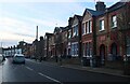
5
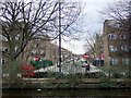
Queens Park Estate
Looking down Sixth Avenue part of the Queens Park estate from upstairs of Gateway Technology Centre, 111 Olliphant Street, W10.
Image: © Phillip Perry
Taken: 6 Feb 2007
0.15 miles
6
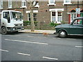
Cat crossing the road - Olliphant Street, W10
A friendly ginger cat crosses Olliphant Street, North Kensington, W10, after meeting me and being photographed.
Image: © Phillip Perry
Taken: 30 Jan 2007
0.16 miles
7
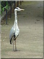
Waiting for a No. 18 bus
This heron was just standing there beside the Harrow Road. Surprising until you realise that with a couple of flaps it could be beside the Grand Union Canal. In Image this bird's position is just on the road side of the railings.
Image: © Roger W Haworth
Taken: 9 Jun 2010
0.16 miles
9
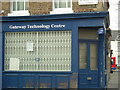
Gateway Technology Centre, W10
On the crossroads of Sixth Avenue and Olliphant Street, looking towards Kilburn Lane.
Image: © Phillip Perry
Taken: 6 Feb 2007
0.16 miles
10
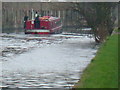
Dusk 'Til Dawn
A houseboat going along the Grand Union Canal towards Little Venice
Image: © Phillip Perry
Taken: 5 Feb 2007
0.17 miles