IMAGES TAKEN NEAR TO
Kilburn Lane, LONDON, W10 4AE
Introduction
This page details the photographs taken nearby to Kilburn Lane, W10 4AE by members of the Geograph project.
The Geograph project started in 2005 with the aim of publishing, organising and preserving representative images for every square kilometre of Great Britain, Ireland and the Isle of Man.

There are currently over 7.5m images from over14,400 individuals and you can help contribute to the project by visiting https://www.geograph.org.uk
Image Map
Images are licensed for reuse under creativecommons.org/licenses/by-sa/2.0
Notes
- Clicking on the map will re-center to the selected point.
- The higher the marker number, the further away the image location is from the centre of the postcode.
Image Listing (262 Images Found)
Images are licensed for reuse under creativecommons.org/licenses/by-sa/2.0
Image
Details
Distance
1
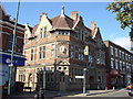
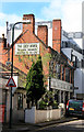
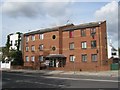
Paradise By Way Of Kensal Green
More on the Paradise By Way Of Kensal Green http://www.theparadise.co.uk/
Image: © Oxyman
Taken: 8 Oct 2008
0.01 miles
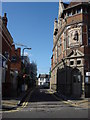
3
Kensal Green, Parlour
Converted pub on Regent Street, formerly Truman's Grey Horse. The interior retains several 1930s features. No cask ale is served.
Image: © Mike Faherty
Taken: 9 Apr 2016
0.02 miles
4
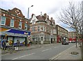
Kensal Green, Paradise
Public house on Kilburn Lane, full name Paradise by Way of Kensal Green. Internally, central bar with front and back rooms, highly decorated with stuccoed ceilings, cages, statuary and urns; outdoor seating. Cask ale on offer at my visit: Timothy Taylor's Landlord.
Image: © Mike Faherty
Taken: 9 Apr 2016
0.02 miles
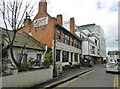
5
The Grey Horse, Regent Street
Tucked away down one of London's lesser known Regent Streets, the Grey Horse looks a long way away from its flamboyant neighbour the "Paradise By Way Of Kensal Green" just over the road. Image As the sign on the wall shows, this was a former Truman's house.
Truman, Hanbury and Buxton was one of the largest breweries in the world around the end of the 19th century.
In the 1970s the brewery was acquired by Grand Metropolitan whose corporate mismanagement crashed the company, causing it to close in 1989. Brewery history on http://en.wikipedia.org/wiki/Truman%27s_Brewery
The Truman's name was revived in 2010 by a new company
http://www.trumansbeer.co.uk/
For those interested in pub / brewery history, this link http://trumanhanburybuxton.tumblr.com/post/335499520/the-grey-horse-5-regent-street-london-nw10-5lg shows the pub under former management when its Trumans identity was removed, fortunately only by temporary signage.
Image: © Des Blenkinsopp
Taken: 7 Apr 2014
0.03 miles
6
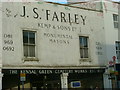
Harrow Road, Kensal Green cemetery stonemasons
Across the road from Kensal green cemetery is this stonemasons shop.
Image: © Phillip Perry
Taken: 26 Feb 2007
0.04 miles
8
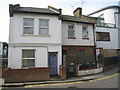
Small town houses
Wellington Road, just off Kilburn Lane.
Image: © Mr Ignavy
Taken: 30 Sep 2010
0.04 miles
10
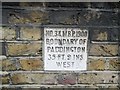
Old Boundary Marker by the B450
Municipal Boundary Marker by the B450, in parish of Paddington Bayswater And Knightsbridge (City Of Westminster District), Kilburn Lane W10, just N of church entrance in wall.
Inscription reads:- : NO.34.M.B.P.1900 / BOUNDARY OF / PADDINGTON / 35 FT. 9 INS. / WEST :
Surveyed
Milestone Society National ID: MX_PADDB34pb.
Image: © Milestone Society
Taken: Unknown
0.05 miles