IMAGES TAKEN NEAR TO
Widewater Place, Moorhall Road, UXBRIDGE, UB9 6NS
Introduction
This page details the photographs taken nearby to Widewater Place, Moorhall Road, UB9 6NS by members of the Geograph project.
The Geograph project started in 2005 with the aim of publishing, organising and preserving representative images for every square kilometre of Great Britain, Ireland and the Isle of Man.

There are currently over 7.5m images from over14,400 individuals and you can help contribute to the project by visiting https://www.geograph.org.uk
Image Map
Images are licensed for reuse under creativecommons.org/licenses/by-sa/2.0
Notes
- Clicking on the map will re-center to the selected point.
- The higher the marker number, the further away the image location is from the centre of the postcode.
Image Listing (120 Images Found)
Images are licensed for reuse under creativecommons.org/licenses/by-sa/2.0
Image
Details
Distance
1
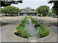
Widewater Place water feature and cafe
A notice on the cafe says it is to open "soon", most of the buildings on this new estate are not yet occupied.
Image: © David Hawgood
Taken: 16 Aug 2021
0.03 miles
2
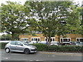
Widewater Place business park on Moorhall Road
Image: © David Howard
Taken: 26 Aug 2014
0.04 miles
5
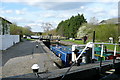
Widewater lock 86
So called because below the lock the canal widens out in a natural basin.
Image: © Graham Horn
Taken: 11 Apr 2010
0.06 miles
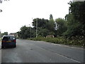
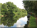
8
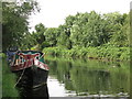
The Grand Union Canal near South Harefield (2)
Image: © Mike Quinn
Taken: 7 Aug 2019
0.07 miles
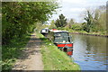
9
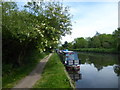
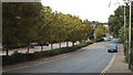
Narrowboat near Widewater Lock on the Grand Union Canal
This section of the Grand Union Canal from the River Thames at Brentford was opened in 1794. It was the first section of what was originally called the Grand Junction Canal. Its purpose was to provide a new, shorter and quicker transport route between London and Birmingham by connecting with a network of canals at Braunston near Daventry. When the canal reached Braunston in 1805 it cut 60 miles off the shortest alternative route.
As you head out of Uxbridge there is much quiet countryside until Rickmansworth is reached. Widewater Lock is immediately to the north of Moorhall Road, just past Harefield Marina. This part of the towpath is also on the London LOOP.
Image: © Marathon
Taken: 22 May 2019
0.07 miles
10
The Grand Union Canal near South Harefield
Image: © Mike Quinn
Taken: 7 Aug 2019
0.07 miles