IMAGES TAKEN NEAR TO
The Alders, Alder Road, UXBRIDGE, UB9 4AY
Introduction
This page details the photographs taken nearby to The Alders, Alder Road, UB9 4AY by members of the Geograph project.
The Geograph project started in 2005 with the aim of publishing, organising and preserving representative images for every square kilometre of Great Britain, Ireland and the Isle of Man.

There are currently over 7.5m images from over14,400 individuals and you can help contribute to the project by visiting https://www.geograph.org.uk
Image Map
Images are licensed for reuse under creativecommons.org/licenses/by-sa/2.0
Notes
- Clicking on the map will re-center to the selected point.
- The higher the marker number, the further away the image location is from the centre of the postcode.
Image Listing (119 Images Found)
Images are licensed for reuse under creativecommons.org/licenses/by-sa/2.0
Image
Details
Distance
1
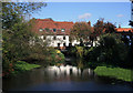
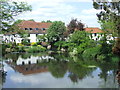
Water Mill on the Colne at Uxbridge
A mid 18C mill on one of the complex of channels which form the lower Colne.
The millstream leaves the main river just by the A40 bridge in the square to the north while the rest of river goes on to join the Grand Union Canal above Uxbridge Lock.
So it's same head of water operating the mill as is going through the lock although the two structures are some way apart. The streams rejoin just downstream of the bridge where I'm standing.
Image: © Des Blenkinsopp
Taken: 17 Oct 2011
0.07 miles
2
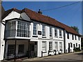
The Old Mill House, Willow Avenue
The building is Grade II listed https://www.historicengland.org.uk/listing/the-list/list-entry/1080147 .
Image: © Mike Quinn
Taken: 5 Jul 2017
0.07 miles
3
Denham, converted mill
With mill stream; seen from Oxford Road.
Image: © Mike Faherty
Taken: 16 Aug 2014
0.08 miles
4
Heron fishing in the River Colne, north of Oxford Road, Uxbridge
Image: © Mike Quinn
Taken: 5 Jul 2017
0.08 miles
5
River Colne, Uxbridge
Housing on the bank of the River Colne in Uxbridge. Uxbridge itself is within Greater London, but these houses are just across the county boundary in Buckinghamshire.
Image: © Malc McDonald
Taken: 2 Jun 2013
0.09 miles
6
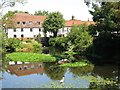
Denham: Willowbank Village
Willowbank Village started off in the 1920s as a collection of small holiday chalets on an island between the River Colne and the Grand Union Canal for Londoners wanting to enjoy the countryside. A few of the original chalets remain today, but most have been demolished and replaced by much larger permanently occupied homes. This is the village green at the centre with Willow Crescent West to the left and Willow Crescent East to the right. Although the village is part of Denham from a local government area point of view, it is much closer to the built-up area of Uxbridge than Denham.
Image: © Nigel Cox
Taken: 10 Aug 2007
0.11 miles
8
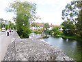
Uxbridge Lock
Lock number 88 on the Grand Union Canal.
Image: © Peter S
Taken: 28 Dec 2016
0.12 miles
9
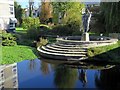
Sculpture below bridge over River Colne
Overlooking the river, just below the Oxford Road High Bridge, is Denham Lodge Image, a block of flats which dates from 1968, and has a private garden on the riverside with a large sculpture of figures playing with a ball, apparently made of plastic but coloured to look like old copper.
http://www.londongardenstrust.org/features/Uxbridge.htm
Image: © Andrew Curtis
Taken: 21 Oct 2018
0.13 miles
10
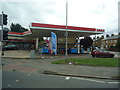
Petrol station, Oxford Road, Uxbridge
Image: © Stacey Harris
Taken: 18 Sep 2013
0.13 miles