IMAGES TAKEN NEAR TO
Derby Road, UXBRIDGE, UB8 2ND
Introduction
This page details the photographs taken nearby to Derby Road, UB8 2ND by members of the Geograph project.
The Geograph project started in 2005 with the aim of publishing, organising and preserving representative images for every square kilometre of Great Britain, Ireland and the Isle of Man.

There are currently over 7.5m images from over14,400 individuals and you can help contribute to the project by visiting https://www.geograph.org.uk
Image Map
Images are licensed for reuse under creativecommons.org/licenses/by-sa/2.0
Notes
- Clicking on the map will re-center to the selected point.
- The higher the marker number, the further away the image location is from the centre of the postcode.
Image Listing (8 Images Found)
Images are licensed for reuse under creativecommons.org/licenses/by-sa/2.0
Image
Details
Distance
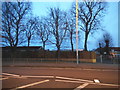
1
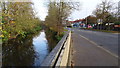
Fray's River and the A408, Cowley Road, Uxbridge
Image: © Rob Emms
Taken: 26 Nov 2016
0.16 miles
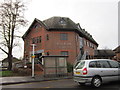
3
Former Chiltern View Tavern, Uxbridge
This former public house on Cowley Road, which has been boarded-up for many years is now repaired and rebuilt into apartments dwellings.
Image: © Rob Emms
Taken: 26 Nov 2016
0.19 miles
4
Fray's River
Running next to Cowley Road
Image: © Ray Stanton
Taken: 20 Jun 2006
0.20 miles
6
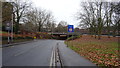
Cricket Field Road, Uxbridge
Cricket Field Road going under Hillingdon Road, the A4020. Just seen, left, south corner of the Civic Centre for London Borough of Hillingdon.
Image: © Rob Emms
Taken: 10 Dec 2016
0.22 miles
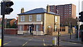
7
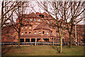
Civic Centre, High Street, Uxbridge
This shows the staff entrance to the Civic Centre offices, home to the London Borough of Hillingdon. LBH came into being in 1965 when local government in London was re-organised. Originally this was Middlesex. To my mind it is only in London by dint of administrative convenience. Uxbridge doesn't have a London postcode or a London telephone number prefix. Parts of it feel much more like the neighbouring counties of Buckinghamshire and Hertfordshire.
Image: © Brian Robert Marshall
Taken: 28 Mar 2003
0.23 miles
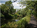
8
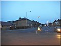
The Greenway at the junction of Cowley Road
Image: © David Howard
Taken: 9 Dec 2017
0.24 miles