IMAGES TAKEN NEAR TO
Waterloo Road, UXBRIDGE, UB8 2FD
Introduction
This page details the photographs taken nearby to Waterloo Road, UB8 2FD by members of the Geograph project.
The Geograph project started in 2005 with the aim of publishing, organising and preserving representative images for every square kilometre of Great Britain, Ireland and the Isle of Man.

There are currently over 7.5m images from over14,400 individuals and you can help contribute to the project by visiting https://www.geograph.org.uk
Image Map
Images are licensed for reuse under creativecommons.org/licenses/by-sa/2.0
Notes
- Clicking on the map will re-center to the selected point.
- The higher the marker number, the further away the image location is from the centre of the postcode.
Image Listing (181 Images Found)
Images are licensed for reuse under creativecommons.org/licenses/by-sa/2.0
Image
Details
Distance
1
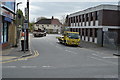
Y. Goldberg & Sons, in Waterloo Road, Uxbridge. (1)
Must be one of the oldest businesses in Uxbridge. Being out of the town centre, has survived decades of redevelopment, but for how long, with the rest of the road now being domestic flats and apartments.
Image: © Rob Emms
Taken: 10 Dec 2016
0.01 miles
2
Uxbridge: Waterloo Wharf redevelopment
Waterloo Wharf by the Grand Union Canal, site being redeveloped into apartments. Note; WWII pillbox, in lower left corner.
Image: © Rob Emms
Taken: 28 Jul 2017
0.01 miles
3
The Grand Union Canal south of the Rockingham Road bridge (no.186) (2)
Image is on the left.
Image: © Mike Quinn
Taken: 5 Jul 2017
0.02 miles
4
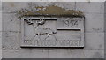
Y. Goldberg & Sons, of Uxbridge (2) wall plaque
Right of main entrance in Waterloo Road, located on side of former terraced house, reads- "Waterloo Wharf 1954".
Image: © Rob Emms
Taken: 3 Dec 2016
0.02 miles
5
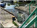
Pillbox built into canal bridge
In the Rockingham Road crossing, Dolphin Bridge, or bridge 186 of the Grand Union Canal. The gun slits are sighted down the canal.
Image: © Robin Webster
Taken: 21 Jul 2013
0.02 miles
6
Pillbox by bridge, overlooking the Grand Union Canal
Canal bridge No.186, with an old concrete WWII pillbox carbuncle.
Image: © Rob Emms
Taken: 30 Nov 2016
0.02 miles
7
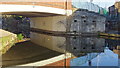
WW2 pillbox at the Rockingham Road bridge (no.186) over the Grand Union Canal
See Image
It's good to know that if the Germans had sent a battleship along the canal they wouldn't have got any closer to central London than this.
Image: © Mike Quinn
Taken: 5 Jul 2017
0.02 miles
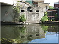
8
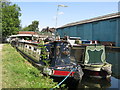
Grand Union Canal pillbox, Uxbridge
The concrete pillbox nestles below the bridge of St John's Road on the east side of the canal which it appears to have guarded. New apartments at Waterloo Wharf can be seen behind the barge.
Another pillbox is known just south Image
In 2016, the remains of a World War 2 pillbox were unearthed close to the Grand Union Canal in Cowley, in the London Borough of Hillingdon.
The fortifications along this part of the Grand Union Canal formed a section of the 'Outer London Defence Ring'. Fabricated in reinforced concrete, the pillboxes included embrasures from which soldiers (usually of the Home Guard), armed with rifles or light machine guns, could fire on advancing enemy troops.
Image: © Andrew Curtis
Taken: 19 Apr 2019
0.02 miles
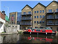
10
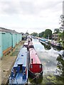
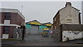
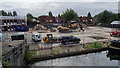
Uxbridge Moor, Grand Union Canal
Looking South from Rock Road Bridge; Uxbridge Boat Centre, left, and moorings, right: https://canalrivertrust.org.uk/canals-and-rivers/grand-union-canal http://www.jim-shead.com/waterways/Articles.php?wpage=86
Image: © Mike Faherty
Taken: 16 Aug 2014
0.02 miles