IMAGES TAKEN NEAR TO
Hinton Road, UXBRIDGE, UB8 2DL
Introduction
This page details the photographs taken nearby to Hinton Road, UB8 2DL by members of the Geograph project.
The Geograph project started in 2005 with the aim of publishing, organising and preserving representative images for every square kilometre of Great Britain, Ireland and the Isle of Man.

There are currently over 7.5m images from over14,400 individuals and you can help contribute to the project by visiting https://www.geograph.org.uk
Image Map
Images are licensed for reuse under creativecommons.org/licenses/by-sa/2.0
Notes
- Clicking on the map will re-center to the selected point.
- The higher the marker number, the further away the image location is from the centre of the postcode.
Image Listing (195 Images Found)
Images are licensed for reuse under creativecommons.org/licenses/by-sa/2.0
Image
Details
Distance
2
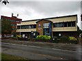
Salvation Army in Cowley Road
Modern purpose built centre.
website : https://www.salvationarmy.org.uk/uxbridge
Image: © James Emmans
Taken: 30 Jul 2019
0.06 miles
3
Kendall Mews, Uxbridge
Vine Street in the foreground, then vehicles on Hillingdon Road, and then dwellings in Kendall Mews.
Image: © Rob Emms
Taken: 7 Jan 2017
0.07 miles
5
Uxbridge Vine Street railway station (site), Greater London
Opened in 1856 by the Great Western Railway as the terminus of its short branch line from West Drayton, this station closed to passengers in 1962 and completely in 1964. The site was later redeveloped.
View north towards the buffers. The railway from West Drayton would have entered from the right of the image, the station site being under the modern building. No trace remains. The former goods shed would have been to the left of the image, under where the road now is.
Image: © Nigel Thompson
Taken: 31 Jul 2018
0.08 miles
7
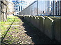
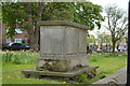
Headstones on the Lynch Green
The burial ground was closed in 1855 and the headstones have been relocated around the perimeter walls.
Image: © Rod Allday
Taken: 7 Mar 2010
0.09 miles
8
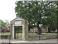
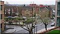
Former graveyard, Cross Street
The land was given for use as a graveyard in 1576; it was closed in 1855 - see Image Now it's a small urban park in the middle of a gyratory system.
Image: © Mike Quinn
Taken: 11 Sep 2019
0.09 miles
9
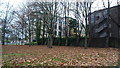
Hertz House, Uxbridge - Rear view, through trees
South east side of Hertz House (left), and south side of Boundary House (right), with autumn leaves and trees.
Image: © Rob Emms
Taken: 10 Dec 2016
0.09 miles