IMAGES TAKEN NEAR TO
George Street, UXBRIDGE, UB8 1QQ
Introduction
This page details the photographs taken nearby to George Street, UB8 1QQ by members of the Geograph project.
The Geograph project started in 2005 with the aim of publishing, organising and preserving representative images for every square kilometre of Great Britain, Ireland and the Isle of Man.

There are currently over 7.5m images from over14,400 individuals and you can help contribute to the project by visiting https://www.geograph.org.uk
Image Map
Images are licensed for reuse under creativecommons.org/licenses/by-sa/2.0
Notes
- Clicking on the map will re-center to the selected point.
- The higher the marker number, the further away the image location is from the centre of the postcode.
Image Listing (262 Images Found)
Images are licensed for reuse under creativecommons.org/licenses/by-sa/2.0
Image
Details
Distance
1
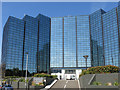
Harman House, George Street
Somewhat narcissistic self-reflections either side of the central section. Overall, not a "friendly" building.
Image: © Mike Quinn
Taken: 5 Jul 2017
0.01 miles
2
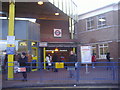
The rear entrance to Uxbridge Tube station
Image: © David Howard
Taken: 30 Dec 2008
0.01 miles
3
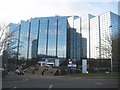
Uxbridge: Harman House
Angled glass fronted buildings can catch the light in strikingly different ways as this view of Harman House from York Way shows.
Image: © Nigel Cox
Taken: 11 Jan 2015
0.02 miles
4
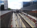
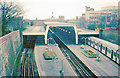
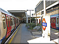
Uxbridge Underground station, Greater London
Opened in 1938 by the London Passenger Transport Board as the terminus of the Metropolitan and Piccadilly lines from London, this station replaced the 1904 station at Belmont Road that had been built by the Metropolitan Railway.
View south west towards the buffers. Like 55% of the London Underground network, this part is actually overground.
Image: © Nigel Thompson
Taken: 31 Jul 2018
0.02 miles
5
Uxbridge Station, 1978
View SW towards buffer-stops: rebuilt on this site in 12/38, it is the LUL terminus of Metropolitan Line from London Baker Street via Harrow-on-the Hill, also Piccadilly Line from Cockfosters via Piccadilly Circus, Acton Town and Rayners Lane.
Image: © Ben Brooksbank
Taken: 2 Apr 1978
0.02 miles
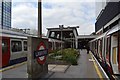
6
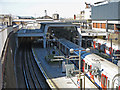
Uxbridge Underground station (4)
Heading towards seven years after Image and this is a full on straight down the centre view into the Grade II Listed station from the York Road bridge. The blue boxes on the platforms have gone, but the biggest change is in the rolling stock with the new Metropolitan Line units having now completely replaced the old. The three track terminal platform arrangements are a little unusual.
Image: © Nigel Cox
Taken: 11 Jan 2015
0.02 miles
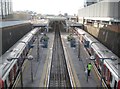
9
Uxbridge tube station
The station, designed by Charles Holden https://en.wikipedia.org/wiki/Charles_Holden with LH Bucknell, opened in late 1938. A tall concrete canopy arches over the tracks with a row of clerestory windows above the platforms https://en.wikipedia.org/wiki/Uxbridge_tube_station . The canopy is similar to the one at Cockfosters, the terminus at the other end of the Piccadilly line - see Image
As at Cockfosters, the station has three tracks and four platforms (numbered 1 to 4): the centre track is between platforms 2 and 3. This is an example of the so-called "Spanish solution" which helps to speed up boarding and alighting https://en.wikipedia.org/wiki/Spanish_solution .
The station is Grade II listed https://www.historicengland.org.uk/listing/the-list/list-entry/1358405 .
Image: © Mike Quinn
Taken: 5 Jul 2017
0.02 miles
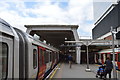
10
Uxbridge tube station (3)
Image: © Mike Quinn
Taken: 5 Jul 2017
0.02 miles