IMAGES TAKEN NEAR TO
Crown Walk, UXBRIDGE, UB8 1GX
Introduction
This page details the photographs taken nearby to Crown Walk, UB8 1GX by members of the Geograph project.
The Geograph project started in 2005 with the aim of publishing, organising and preserving representative images for every square kilometre of Great Britain, Ireland and the Isle of Man.

There are currently over 7.5m images from over14,400 individuals and you can help contribute to the project by visiting https://www.geograph.org.uk
Image Map
Images are licensed for reuse under creativecommons.org/licenses/by-sa/2.0
Notes
- Clicking on the map will re-center to the selected point.
- The higher the marker number, the further away the image location is from the centre of the postcode.
Image Listing (288 Images Found)
Images are licensed for reuse under creativecommons.org/licenses/by-sa/2.0
Image
Details
Distance
1
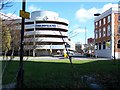
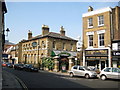
The Pavilions, Uxbridge
Looking across Cross Street and down Grainges yard. The entrance of Grainges car park and the delivery entrance for The Pavilions shopping Mall.
Image: © Rob Emms
Taken: 18 Mar 2007
0.04 miles
2
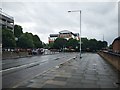
Oxford Road
Main road close Uxbridge town centre.
Image: © James Emmans
Taken: 30 Jul 2019
0.05 miles
3
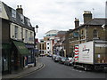
Windsor Street Uxbridge
The Fig Tree pub on the right used to be the Police Station. Uxbridge was an important market town and coaching stop in the past, with many fine old buildings. Unfortunately it suffered in the 1960s from redevelopment which can best be described as vandalism and most of the old buildings have disappeared, with the town consequently losing its character. Windsor Street is one of the few remaining old parts of the town. The scene is marred by the office building in the distance, which is typical of modern Uxbridge.
Image: © Rod Allday
Taken: 25 Jun 2008
0.06 miles
4
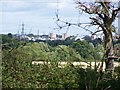
Distant Uxbridge
The two cream buildings are 2,700 metres from camera. Photograph taken from Cycle Route 61.
Image: © Rob Emms
Taken: 19 Aug 2017
0.06 miles
5
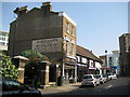
Uxbridge: Windsor Street (1)
Prominent in the photograph is The Fig Tree public house, a Greene King outlet. This was originally built as the town's police station, but was later converted to a public house with the inevitable name of The Old Bill. The transformation to The Fig Tree is recent, from around the beginning of 2006. Apparently and allegedly the new name had to fit to the number of letters of the old name on the outside of the building to circumvent certain planning regulations! Barnard's Bookshop is to the right.
Image: © Nigel Cox
Taken: 11 May 2008
0.07 miles
6
Uxbridge: Windsor Street (2)
Windsor Street is one of the few surviving thoroughfares in the centre of Uxbridge to have retained some of its historic buildings. Barnard's University Bookshop is prominent here. The north tower of Image is just visible on the right.
Image: © Nigel Cox
Taken: 11 May 2008
0.07 miles
7
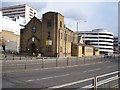
Our Lady of Lourdes & St. Michael R.C. Church
One of a few large buildings to survive the modernization of Uxbridge's town centre. Mainly due to luck, I think. Situated on the side of the busy A4020 Oxford Road.
Image: © Rob Emms
Taken: 29 Mar 2007
0.07 miles
8
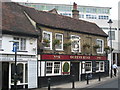
The Queen's Head pub Uxbridge
Dating from 1546, this is reputed to be the oldest pub in Uxbridge, a town which had a large number of coaching inns, being on the route from London to Oxford.
Image: © Rod Allday
Taken: 25 Jun 2008
0.08 miles
9
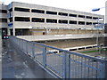
Uxbridge: The Pavilions
A multi-storey car park at The Pavilions shopping mall, viewed from the pedestrian footbridge over the A4020 Oxford Road.
Image: © Nigel Cox
Taken: 21 Jan 2007
0.08 miles
10
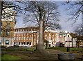
The Angel is Looking Down !
St. Margaret's Old Burial Ground, unused for the past 150 years. Most head stones have now gone. The site is now the home for Uxbridge's War Memorial [since 1972]. The Old Post Office is to the rear. Capital Court to the left. Just visible, are cars parked in Windsor Street. This small piece of greenery is surrounded by a four lane, one way road system.
Image: © Rob Emms
Taken: 28 Jan 2007
0.08 miles